

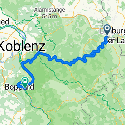
Gückingen-Balduinstein-Diez
A cycling route starting in Aull, Rhineland-Palatinate, Germany.
Overview
About this route
- -:--
- Duration
- 23.3 km
- Distance
- 396 m
- Ascent
- 396 m
- Descent
- ---
- Avg. speed
- ---
- Max. altitude
Route quality
Waytypes & surfaces along the route
Waytypes
Track
11.3 km
(48 %)
Road
3.9 km
(17 %)
Surfaces
Paved
17.6 km
(76 %)
Unpaved
4 km
(17 %)
Asphalt
17.2 km
(74 %)
Gravel
2.9 km
(13 %)
Continue with Bikemap
Use, edit, or download this cycling route
You would like to ride Gückingen-Balduinstein-Diez or customize it for your own trip? Here is what you can do with this Bikemap route:
Free features
- Save this route as favorite or in collections
- Copy & plan your own version of this route
- Sync your route with Garmin or Wahoo
Premium features
Free trial for 3 days, or one-time payment. More about Bikemap Premium.
- Navigate this route on iOS & Android
- Export a GPX / KML file of this route
- Create your custom printout (try it for free)
- Download this route for offline navigation
Discover more Premium features.
Get Bikemap PremiumFrom our community
Other popular routes starting in Aull
 Gückingen-Obernhof/Lahn
- Distance
- 18.6 km
- Ascent
- 320 m
- Descent
- 408 m
- Location
- Aull, Rhineland-Palatinate, Germany
 Tierheim
- Distance
- 20 km
- Ascent
- 121 m
- Descent
- 193 m
- Location
- Aull, Rhineland-Palatinate, Germany
 4.Fahrt
- Distance
- 72.4 km
- Ascent
- 1,164 m
- Descent
- 1,217 m
- Location
- Aull, Rhineland-Palatinate, Germany
 Von Gückingen bis Kamp-Bornhofen
- Distance
- 70.8 km
- Ascent
- 1,046 m
- Descent
- 1,157 m
- Location
- Aull, Rhineland-Palatinate, Germany
 Gückingen-Balduinstein-Diez
- Distance
- 23.3 km
- Ascent
- 396 m
- Descent
- 396 m
- Location
- Aull, Rhineland-Palatinate, Germany
 Gückingen-Westerburg-Elbtal-Hadamar-Gückingen
- Distance
- 57.9 km
- Ascent
- 471 m
- Descent
- 471 m
- Location
- Aull, Rhineland-Palatinate, Germany
 3.etappe
- Distance
- 70.9 km
- Ascent
- 1,100 m
- Descent
- 1,155 m
- Location
- Aull, Rhineland-Palatinate, Germany
Open it in the app