
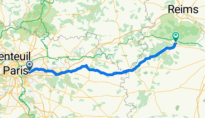
Paris 2 Epernay
A cycling route starting in Fontenay-sous-Bois, Île-de-France Region, France.
Overview
About this route
- -:--
- Duration
- 130.5 km
- Distance
- 523 m
- Ascent
- 512 m
- Descent
- ---
- Avg. speed
- ---
- Max. altitude
Route quality
Waytypes & surfaces along the route
Waytypes
Road
55.4 km
(42 %)
Busy road
39.8 km
(30 %)
Surfaces
Paved
55.9 km
(43 %)
Asphalt
55.9 km
(43 %)
Wood
0 km
(<1 %)
Undefined
74.6 km
(57 %)
Continue with Bikemap
Use, edit, or download this cycling route
You would like to ride Paris 2 Epernay or customize it for your own trip? Here is what you can do with this Bikemap route:
Free features
- Save this route as favorite or in collections
- Copy & plan your own version of this route
- Split it into stages to create a multi-day tour
- Sync your route with Garmin or Wahoo
Premium features
Free trial for 3 days, or one-time payment. More about Bikemap Premium.
- Navigate this route on iOS & Android
- Export a GPX / KML file of this route
- Create your custom printout (try it for free)
- Download this route for offline navigation
Discover more Premium features.
Get Bikemap PremiumFrom our community
Other popular routes starting in Fontenay-sous-Bois
 travail domicile
- Distance
- 3.3 km
- Ascent
- 55 m
- Descent
- 41 m
- Location
- Fontenay-sous-Bois, Île-de-France Region, France
 Montreuil - Beauchemin 285km
- Distance
- 284.5 km
- Ascent
- 797 m
- Descent
- 497 m
- Location
- Fontenay-sous-Bois, Île-de-France Region, France
 Paris 2 Epernay
- Distance
- 130.5 km
- Ascent
- 523 m
- Descent
- 512 m
- Location
- Fontenay-sous-Bois, Île-de-France Region, France
 Rue Mauconseil, Fontenay-sous-Bois à Place du Général Leclerc, Fontenay-sous-Bois
- Distance
- 18.1 km
- Ascent
- 59 m
- Descent
- 55 m
- Location
- Fontenay-sous-Bois, Île-de-France Region, France
 Fontenay _ Villenoy
- Distance
- 44.5 km
- Ascent
- 74 m
- Descent
- 127 m
- Location
- Fontenay-sous-Bois, Île-de-France Region, France
 De Saint-Exupery à Avenue Paul Vaillant Couturier
- Distance
- 16.3 km
- Ascent
- 122 m
- Descent
- 121 m
- Location
- Fontenay-sous-Bois, Île-de-France Region, France
 CAP_velo
- Distance
- 147.7 km
- Ascent
- 602 m
- Descent
- 668 m
- Location
- Fontenay-sous-Bois, Île-de-France Region, France
 boucle 65 km Montreuil
- Distance
- 65.2 km
- Ascent
- 393 m
- Descent
- 393 m
- Location
- Fontenay-sous-Bois, Île-de-France Region, France
Open it in the app