
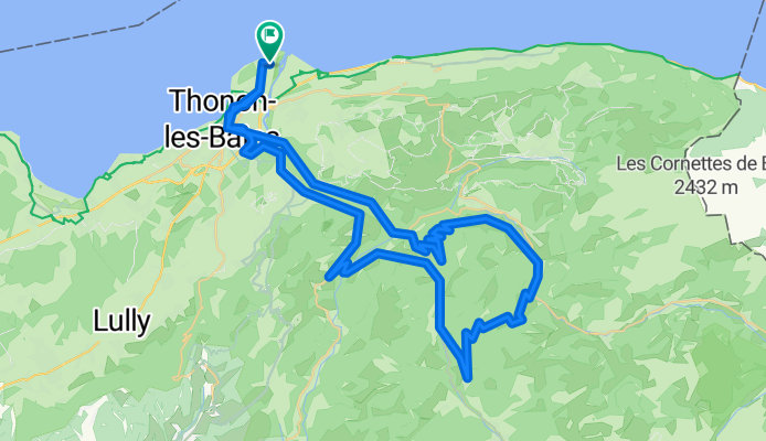
Thonon-les-Bains - Col du Corbier - Col du Grand Taillet 76km-1450m
A cycling route starting in Publier, Auvergne-Rhône-Alpes, France.
Overview
About this route
Eine sehr schöne und anspruchsvolle Runde über zwei kleine Pässe. Abseits der D902 (Grand Routes des Alpes) sind die Straßen ziemlich verkehrsarm und bieten absoluten Fahrradgenuss bei toller Landschaftskulisse. Ich bin die Tour gegen den Uhrzeigersinn gefahren.
Der Col du Corbier von Gys (Westauffahrt) ist knackig. Die Steigung fällt auf den letzten 4,5km selten unter 9-10% mit einigen kürzeren Spitzen auf 13-14%. Die Abfahrt ist ein Genuss. Der Anstieg zum kleinen Col du Grand Taillet beginnt zahm und legt dann auf den letzten 2,5km ein paar Schippen auf 7-10% drauf. Die Abfahrt auf der D102 hinunter ins Tal der Dranse ist sehr lohnenswert.
(Mein Garmin Fenix5 hat "nur" 1450 Hm aufgezeichnet)
- -:--
- Duration
- 75.6 km
- Distance
- 1,349 m
- Ascent
- 1,349 m
- Descent
- ---
- Avg. speed
- ---
- Max. altitude

Route quality
Waytypes & surfaces along the route
Waytypes
Road
32.6 km
(43 %)
Busy road
26.1 km
(35 %)
Surfaces
Paved
54.6 km
(72 %)
Unpaved
1.1 km
(1 %)
Asphalt
54.6 km
(72 %)
Gravel
1 km
(1 %)
Continue with Bikemap
Use, edit, or download this cycling route
You would like to ride Thonon-les-Bains - Col du Corbier - Col du Grand Taillet 76km-1450m or customize it for your own trip? Here is what you can do with this Bikemap route:
Free features
- Save this route as favorite or in collections
- Copy & plan your own version of this route
- Sync your route with Garmin or Wahoo
Premium features
Free trial for 3 days, or one-time payment. More about Bikemap Premium.
- Navigate this route on iOS & Android
- Export a GPX / KML file of this route
- Create your custom printout (try it for free)
- Download this route for offline navigation
Discover more Premium features.
Get Bikemap PremiumFrom our community
Other popular routes starting in Publier
 2 Park Dranse - Bois Noir
- Distance
- 57.7 km
- Ascent
- 245 m
- Descent
- 165 m
- Location
- Publier, Auvergne-Rhône-Alpes, France
 RdGA 2022 - Tag 1
- Distance
- 90.7 km
- Ascent
- 2,861 m
- Descent
- 2,165 m
- Location
- Publier, Auvergne-Rhône-Alpes, France
 Allinges
- Distance
- 15.8 km
- Ascent
- 178 m
- Descent
- 176 m
- Location
- Publier, Auvergne-Rhône-Alpes, France
 RdGA 2022 - Tag 1 - Variante
- Distance
- 87.9 km
- Ascent
- 2,524 m
- Descent
- 1,842 m
- Location
- Publier, Auvergne-Rhône-Alpes, France
 Corsier
- Distance
- 76.8 km
- Ascent
- 640 m
- Descent
- 635 m
- Location
- Publier, Auvergne-Rhône-Alpes, France
 CPR Col de Cou et Col des Moises
- Distance
- 60.8 km
- Ascent
- 956 m
- Descent
- 952 m
- Location
- Publier, Auvergne-Rhône-Alpes, France
 Thonon-les-Bains - Col du Corbier - Col du Grand Taillet 76km-1450m
- Distance
- 75.6 km
- Ascent
- 1,349 m
- Descent
- 1,349 m
- Location
- Publier, Auvergne-Rhône-Alpes, France
 Lugrin
- Distance
- 37.7 km
- Ascent
- 501 m
- Descent
- 500 m
- Location
- Publier, Auvergne-Rhône-Alpes, France
Open it in the app