

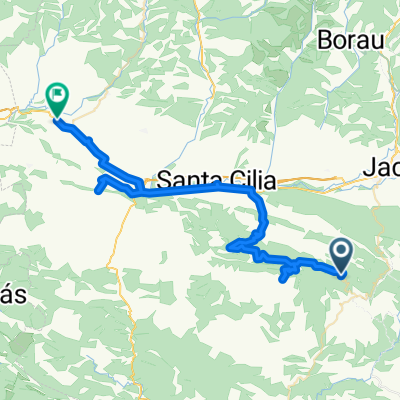
Subida de 10.5 km
A cycling route starting in Santa Cruz de la Serós, Aragon, Spain.
Overview
About this route
Climb with good asphalt and some brief breaks that won't affect the test results. It's recommended not to start at full effort but to give it your all in the last 5 km. Let's go for it!
- -:--
- Duration
- 10.4 km
- Distance
- 462 m
- Ascent
- 140 m
- Descent
- ---
- Avg. speed
- ---
- Max. altitude

Continue with Bikemap
Use, edit, or download this cycling route
You would like to ride Subida de 10.5 km or customize it for your own trip? Here is what you can do with this Bikemap route:
Free features
- Save this route as favorite or in collections
- Copy & plan your own version of this route
- Sync your route with Garmin or Wahoo
Premium features
Free trial for 3 days, or one-time payment. More about Bikemap Premium.
- Navigate this route on iOS & Android
- Export a GPX / KML file of this route
- Create your custom printout (try it for free)
- Download this route for offline navigation
Discover more Premium features.
Get Bikemap PremiumFrom our community
Other popular routes starting in Santa Cruz de la Serós
 Zuriza-Belagüa
- Distance
- 132.3 km
- Ascent
- 1,505 m
- Descent
- 1,505 m
- Location
- Santa Cruz de la Serós, Aragon, Spain
 Santa Cruz de la Serós - Mianos
- Distance
- 55.4 km
- Ascent
- 0 m
- Descent
- 543 m
- Location
- Santa Cruz de la Serós, Aragon, Spain
 Bicitour2016-P
- Distance
- 46.1 km
- Ascent
- 392 m
- Descent
- 409 m
- Location
- Santa Cruz de la Serós, Aragon, Spain
 Bailo - Yésero
- Distance
- 37.6 km
- Ascent
- 1,109 m
- Descent
- 956 m
- Location
- Santa Cruz de la Serós, Aragon, Spain
 San Juan de la peña- Monrepos- Oroel
- Distance
- 138.2 km
- Ascent
- 1,881 m
- Descent
- 1,882 m
- Location
- Santa Cruz de la Serós, Aragon, Spain
 Santa Cruz de la Serós - Sallent de Gállego
- Distance
- 80.1 km
- Ascent
- 2,527 m
- Descent
- 2,036 m
- Location
- Santa Cruz de la Serós, Aragon, Spain
 '3-Camino - San Juan de la Peña
- Distance
- 12.1 km
- Ascent
- 671 m
- Descent
- 127 m
- Location
- Santa Cruz de la Serós, Aragon, Spain
 Subida de 10.5 km
- Distance
- 10.4 km
- Ascent
- 462 m
- Descent
- 140 m
- Location
- Santa Cruz de la Serós, Aragon, Spain
Open it in the app