

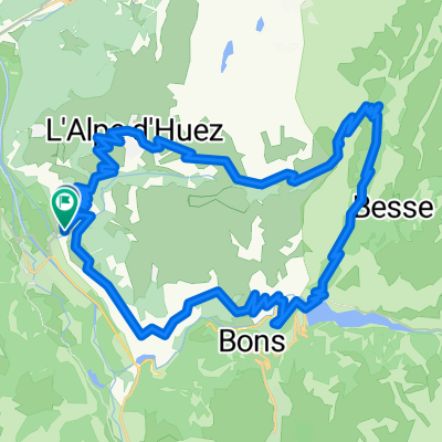
LDA 07c - Bourg d'Oisans - Braincon
A cycling route starting in Huez, Auvergne-Rhône-Alpes, France.
Overview
About this route
- -:--
- Duration
- 96.6 km
- Distance
- 2,571 m
- Ascent
- 1,937 m
- Descent
- ---
- Avg. speed
- ---
- Max. altitude
Route quality
Waytypes & surfaces along the route
Waytypes
Road
6.8 km
(7 %)
Cycleway
4.8 km
(5 %)
Surfaces
Paved
79.2 km
(82 %)
Asphalt
79.2 km
(82 %)
Undefined
17.4 km
(18 %)
Continue with Bikemap
Use, edit, or download this cycling route
You would like to ride LDA 07c - Bourg d'Oisans - Braincon or customize it for your own trip? Here is what you can do with this Bikemap route:
Free features
- Save this route as favorite or in collections
- Copy & plan your own version of this route
- Split it into stages to create a multi-day tour
- Sync your route with Garmin or Wahoo
Premium features
Free trial for 3 days, or one-time payment. More about Bikemap Premium.
- Navigate this route on iOS & Android
- Export a GPX / KML file of this route
- Create your custom printout (try it for free)
- Download this route for offline navigation
Discover more Premium features.
Get Bikemap PremiumFrom our community
Other popular routes starting in Huez
 Tour du plateau matheysin par laffrey
- Distance
- 97.9 km
- Ascent
- 1,505 m
- Descent
- 1,505 m
- Location
- Huez, Auvergne-Rhône-Alpes, France
 La Marmotte
- Distance
- 174.3 km
- Ascent
- 4,523 m
- Descent
- 3,559 m
- Location
- Huez, Auvergne-Rhône-Alpes, France
 Alpe d-Huez boucle
- Distance
- 48.9 km
- Ascent
- 1,639 m
- Descent
- 1,714 m
- Location
- Huez, Auvergne-Rhône-Alpes, France
 Classic Climbs - Day 1b - Col Du Galibier
- Distance
- 47.2 km
- Ascent
- 2,437 m
- Descent
- 550 m
- Location
- Huez, Auvergne-Rhône-Alpes, France
 Mein La Marmotte 2010
- Distance
- 173.8 km
- Ascent
- 4,517 m
- Descent
- 3,432 m
- Location
- Huez, Auvergne-Rhône-Alpes, France
 Glandon/Croix de Fer - Alpe d'Huez - Sarenne
- Distance
- 122.4 km
- Ascent
- 2,642 m
- Descent
- 2,643 m
- Location
- Huez, Auvergne-Rhône-Alpes, France
 Glandon - Croix de Fer
- Distance
- 65.5 km
- Ascent
- 1,611 m
- Descent
- 1,611 m
- Location
- Huez, Auvergne-Rhône-Alpes, France
 Alpe d`Huez
- Distance
- 14.2 km
- Ascent
- 1,183 m
- Descent
- 70 m
- Location
- Huez, Auvergne-Rhône-Alpes, France
Open it in the app