
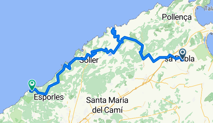
20180822 SA POBLA-SA BATAIA-COLL DES REIS (x2 Sa CALOBRA)-SÓLLER-DEIÀ-BANYALBUFAR
A cycling route starting in sa Pobla, Balearic Islands, Spain.
Overview
About this route
Departure at 7 to enjoy a mountain stage in the morning
115.17 km in 5h25'15"
- -:--
- Duration
- 116.5 km
- Distance
- 2,307 m
- Ascent
- 2,175 m
- Descent
- ---
- Avg. speed
- ---
- Max. altitude

Route quality
Waytypes & surfaces along the route
Waytypes
Road
65.3 km
(56 %)
Quiet road
10.5 km
(9 %)
Undefined
40.8 km
(35 %)
Surfaces
Paved
114.2 km
(98 %)
Asphalt
114.2 km
(98 %)
Undefined
2.3 km
(2 %)
Continue with Bikemap
Use, edit, or download this cycling route
You would like to ride 20180822 SA POBLA-SA BATAIA-COLL DES REIS (x2 Sa CALOBRA)-SÓLLER-DEIÀ-BANYALBUFAR or customize it for your own trip? Here is what you can do with this Bikemap route:
Free features
- Save this route as favorite or in collections
- Copy & plan your own version of this route
- Split it into stages to create a multi-day tour
- Sync your route with Garmin or Wahoo
Premium features
Free trial for 3 days, or one-time payment. More about Bikemap Premium.
- Navigate this route on iOS & Android
- Export a GPX / KML file of this route
- Create your custom printout (try it for free)
- Download this route for offline navigation
Discover more Premium features.
Get Bikemap PremiumFrom our community
Other popular routes starting in sa Pobla
 20170412 Sa Pobla-Sa Batalla-Sa Calobra-Port de Sòller-Bunyola-Orient-Sa Pobla
- Distance
- 149.5 km
- Ascent
- 2,711 m
- Descent
- 2,713 m
- Location
- sa Pobla, Balearic Islands, Spain
 sa pobla to cap de formentor via Alcudia and back via Pollenca
- Distance
- 86 km
- Ascent
- 694 m
- Descent
- 694 m
- Location
- sa Pobla, Balearic Islands, Spain
 20180822 SA POBLA-SA BATAIA-COLL DES REIS (x2 Sa CALOBRA)-SÓLLER-DEIÀ-BANYALBUFAR
- Distance
- 116.5 km
- Ascent
- 2,307 m
- Descent
- 2,175 m
- Location
- sa Pobla, Balearic Islands, Spain
 Mountain route from Crestatx to Lluc on Mallorca
- Distance
- 59.1 km
- Ascent
- 780 m
- Descent
- 780 m
- Location
- sa Pobla, Balearic Islands, Spain
 20191228 Sa Pobla-Far Formentor-Lluc-Sa Poblade
- Distance
- 111.2 km
- Ascent
- 1,284 m
- Descent
- 1,284 m
- Location
- sa Pobla, Balearic Islands, Spain
 Streckenteil 1 durch die Berge
- Distance
- 53.5 km
- Ascent
- 1,843 m
- Descent
- 1,580 m
- Location
- sa Pobla, Balearic Islands, Spain
 Mallorca #5
- Distance
- 83.4 km
- Ascent
- 811 m
- Descent
- 810 m
- Location
- sa Pobla, Balearic Islands, Spain
 LA PUEBLA-CAMPANET-POLLENSA-FARO FORMENTOR-POLLENSA-ALCUDIA-LA ALBUFERA-LA PUEBLA
- Distance
- 92.9 km
- Ascent
- 685 m
- Descent
- 688 m
- Location
- sa Pobla, Balearic Islands, Spain
Open it in the app