

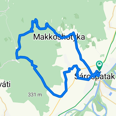
Sárospatak - Kassa
A cycling route starting in Sárospatak, Borsod-Abauj Zemplen county, Hungary.
Overview
About this route
Sárospatak – Sátoraljaújhely – Füzér – Hollóháza – Eszkáros - Kassa – Abaújszina (Sena) – Vizsoly – Boldogkőváralja – Regéc – Tolcsva - Sárospatak
- -:--
- Duration
- 189.1 km
- Distance
- 882 m
- Ascent
- 882 m
- Descent
- ---
- Avg. speed
- ---
- Max. altitude

Route quality
Waytypes & surfaces along the route
Waytypes
Road
30.3 km
(16 %)
Quiet road
26.5 km
(14 %)
Surfaces
Paved
68.1 km
(36 %)
Unpaved
17 km
(9 %)
Asphalt
68.1 km
(36 %)
Ground
13.2 km
(7 %)
Continue with Bikemap
Use, edit, or download this cycling route
You would like to ride Sárospatak - Kassa or customize it for your own trip? Here is what you can do with this Bikemap route:
Free features
- Save this route as favorite or in collections
- Copy & plan your own version of this route
- Split it into stages to create a multi-day tour
- Sync your route with Garmin or Wahoo
Premium features
Free trial for 3 days, or one-time payment. More about Bikemap Premium.
- Navigate this route on iOS & Android
- Export a GPX / KML file of this route
- Create your custom printout (try it for free)
- Download this route for offline navigation
Discover more Premium features.
Get Bikemap PremiumFrom our community
Other popular routes starting in Sárospatak
 STEREO 10.4 Gerendás-rét - Pálháza
- Distance
- 11.5 km
- Ascent
- 26 m
- Descent
- 304 m
- Location
- Sárospatak, Borsod-Abauj Zemplen county, Hungary
 Sp-Kolóska-Újhuta-Hotyka-Sp
- Distance
- 43.1 km
- Ascent
- 663 m
- Descent
- 663 m
- Location
- Sárospatak, Borsod-Abauj Zemplen county, Hungary
 Három országban, két keréken, egy nemzetért
- Distance
- 170.7 km
- Ascent
- 339 m
- Descent
- 357 m
- Location
- Sárospatak, Borsod-Abauj Zemplen county, Hungary
 Patak-Pálháza-Gönc-Pálháza-Patak
- Distance
- 103.2 km
- Ascent
- 470 m
- Descent
- 470 m
- Location
- Sárospatak, Borsod-Abauj Zemplen county, Hungary
 Bringahorda 2017
- Distance
- 139.6 km
- Ascent
- 1,176 m
- Descent
- 1,176 m
- Location
- Sárospatak, Borsod-Abauj Zemplen county, Hungary
 Hercegkút tour
- Distance
- 32.7 km
- Ascent
- 472 m
- Descent
- 472 m
- Location
- Sárospatak, Borsod-Abauj Zemplen county, Hungary
 Kerek kő 1.
- Distance
- 2.3 km
- Ascent
- 150 m
- Descent
- 21 m
- Location
- Sárospatak, Borsod-Abauj Zemplen county, Hungary
 pünkösd túra 2015
- Distance
- 126.5 km
- Ascent
- 639 m
- Descent
- 642 m
- Location
- Sárospatak, Borsod-Abauj Zemplen county, Hungary
Open it in the app