

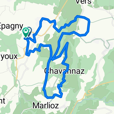
Circuit autour du Vuache, 54 km
A cycling route starting in Valleiry, Auvergne-Rhône-Alpes, France.
Overview
About this route
- -:--
- Duration
- 54.1 km
- Distance
- 938 m
- Ascent
- 937 m
- Descent
- ---
- Avg. speed
- ---
- Max. altitude
Route photos


Route quality
Waytypes & surfaces along the route
Waytypes
Road
46.5 km
(86 %)
Quiet road
1.6 km
(3 %)
Surfaces
Paved
14.6 km
(27 %)
Unpaved
1.1 km
(2 %)
Asphalt
14.6 km
(27 %)
Gravel
0.5 km
(1 %)
Route highlights
Points of interest along the route
Point of interest after 30.4 km
Château de Clermont
Point of interest after 45.1 km
Château de Chaumont
Continue with Bikemap
Use, edit, or download this cycling route
You would like to ride Circuit autour du Vuache, 54 km or customize it for your own trip? Here is what you can do with this Bikemap route:
Free features
- Save this route as favorite or in collections
- Copy & plan your own version of this route
- Sync your route with Garmin or Wahoo
Premium features
Free trial for 3 days, or one-time payment. More about Bikemap Premium.
- Navigate this route on iOS & Android
- Export a GPX / KML file of this route
- Create your custom printout (try it for free)
- Download this route for offline navigation
Discover more Premium features.
Get Bikemap PremiumFrom our community
Other popular routes starting in Valleiry
 De Chemin de Fontanille à Chemin de Fontanille
- Distance
- 25.3 km
- Ascent
- 654 m
- Descent
- 714 m
- Location
- Valleiry, Auvergne-Rhône-Alpes, France
 Vulbens/Belmont-Tramonet
- Distance
- 91.8 km
- Ascent
- 266 m
- Descent
- 519 m
- Location
- Valleiry, Auvergne-Rhône-Alpes, France
 Campagne GE (85km)
- Distance
- 84.5 km
- Ascent
- 870 m
- Descent
- 872 m
- Location
- Valleiry, Auvergne-Rhône-Alpes, France
 Tour moto dans l'Ain avec passage à Bolozon
- Distance
- 172.6 km
- Ascent
- 2,435 m
- Descent
- 2,404 m
- Location
- Valleiry, Auvergne-Rhône-Alpes, France
 De Route de Novery à Lotissement des Tirée
- Distance
- 18.9 km
- Ascent
- 453 m
- Descent
- 502 m
- Location
- Valleiry, Auvergne-Rhône-Alpes, France
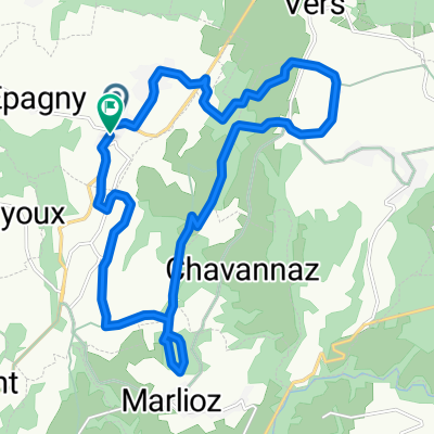
 Autour du mont Vuache
- Distance
- 52.1 km
- Ascent
- 742 m
- Descent
- 742 m
- Location
- Valleiry, Auvergne-Rhône-Alpes, France
 Thonon-les-Bains nach Armoy
- Distance
- 1,266.9 km
- Ascent
- 11,375 m
- Descent
- 11,383 m
- Location
- Valleiry, Auvergne-Rhône-Alpes, France
 Circuit autour du Vuache, 54 km
- Distance
- 54.1 km
- Ascent
- 938 m
- Descent
- 937 m
- Location
- Valleiry, Auvergne-Rhône-Alpes, France
Open it in the app