

Alpannonia complete 6
A cycling route starting in Unterkohlstätten, Burgenland, Austria.
Overview
About this route
Alpannonia
Unterkohlstätten
Oberkohlstätten
Kleiner Hirschenstein (836 m)
Grosser Hirschenstein (862 m)
Landesehrenmal
Geschriebenstein / Írott-kő (884 m)
Hörmann-forrás
Stájerházak
Szikla-forrás
Zeiger-nyereg
Óház-tető
Kőszeg
- -:--
- Duration
- 27.7 km
- Distance
- 651 m
- Ascent
- 887 m
- Descent
- ---
- Avg. speed
- ---
- Max. altitude

Continue with Bikemap
Use, edit, or download this cycling route
You would like to ride Alpannonia complete 6 or customize it for your own trip? Here is what you can do with this Bikemap route:
Free features
- Save this route as favorite or in collections
- Copy & plan your own version of this route
- Sync your route with Garmin or Wahoo
Premium features
Free trial for 3 days, or one-time payment. More about Bikemap Premium.
- Navigate this route on iOS & Android
- Export a GPX / KML file of this route
- Create your custom printout (try it for free)
- Download this route for offline navigation
Discover more Premium features.
Get Bikemap PremiumFrom our community
Other popular routes starting in Unterkohlstätten
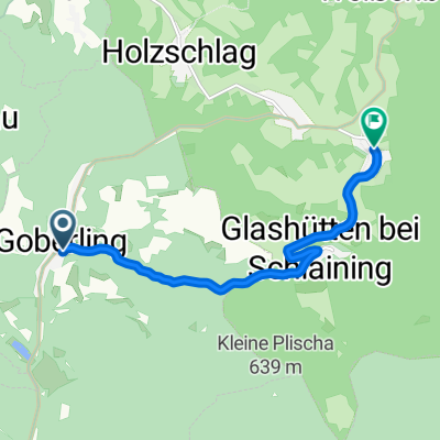 Goberling nach Oberkohlstätten
- Distance
- 7.1 km
- Ascent
- 273 m
- Descent
- 90 m
- Location
- Unterkohlstätten, Burgenland, Austria
 Alpannonia complete 6
- Distance
- 27.7 km
- Ascent
- 651 m
- Descent
- 887 m
- Location
- Unterkohlstätten, Burgenland, Austria
 Unterkohlstaten
- Distance
- 28.7 km
- Ascent
- 463 m
- Descent
- 453 m
- Location
- Unterkohlstätten, Burgenland, Austria
 Alpannonia Fischbach 6
- Distance
- 27.2 km
- Ascent
- 641 m
- Descent
- 877 m
- Location
- Unterkohlstätten, Burgenland, Austria
 Geschriebensteinrunde
- Distance
- 66.6 km
- Ascent
- 544 m
- Descent
- 544 m
- Location
- Unterkohlstätten, Burgenland, Austria
 Goberling-Žice
- Distance
- 115.4 km
- Ascent
- 512 m
- Descent
- 574 m
- Location
- Unterkohlstätten, Burgenland, Austria
 Unterkohlstätten 58 nach L356 31, Oberschützen
- Distance
- 22.3 km
- Ascent
- 435 m
- Descent
- 450 m
- Location
- Unterkohlstätten, Burgenland, Austria
 Hirscheinsteingegend
- Distance
- 27.7 km
- Ascent
- 658 m
- Descent
- 660 m
- Location
- Unterkohlstätten, Burgenland, Austria
Open it in the app