

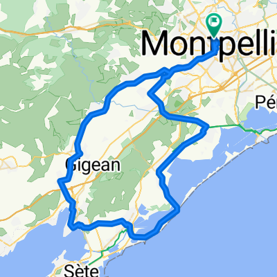
Montepellier-AiguesMortes
A cycling route starting in Montpellier, Occitanie, France.
Overview
About this route
- -:--
- Duration
- 42.5 km
- Distance
- 4 m
- Ascent
- 55 m
- Descent
- ---
- Avg. speed
- ---
- Max. altitude
Route quality
Waytypes & surfaces along the route
Waytypes
Path
14 km
(33 %)
Cycleway
14 km
(33 %)
Surfaces
Paved
33.6 km
(79 %)
Asphalt
29.8 km
(70 %)
Paved (undefined)
3.4 km
(8 %)
Continue with Bikemap
Use, edit, or download this cycling route
You would like to ride Montepellier-AiguesMortes or customize it for your own trip? Here is what you can do with this Bikemap route:
Free features
- Save this route as favorite or in collections
- Copy & plan your own version of this route
- Sync your route with Garmin or Wahoo
Premium features
Free trial for 3 days, or one-time payment. More about Bikemap Premium.
- Navigate this route on iOS & Android
- Export a GPX / KML file of this route
- Create your custom printout (try it for free)
- Download this route for offline navigation
Discover more Premium features.
Get Bikemap PremiumFrom our community
Other popular routes starting in Montpellier
 Petit classique 77
- Distance
- 77 km
- Ascent
- 540 m
- Descent
- 540 m
- Location
- Montpellier, Occitanie, France
 Tour de France 2009, Etappe 4 - 30,0 km
- Distance
- 39 km
- Ascent
- 372 m
- Descent
- 367 m
- Location
- Montpellier, Occitanie, France
 OPT9_montpelliers_cerbere
- Distance
- 233 km
- Ascent
- 217 m
- Descent
- 260 m
- Location
- Montpellier, Occitanie, France
 Montpellier Nord - Pic Saint Loup
- Distance
- 69.1 km
- Ascent
- 439 m
- Descent
- 439 m
- Location
- Montpellier, Occitanie, France
 Vivons Vélo Rassemblement du 1er juillet 2017
- Distance
- 27.1 km
- Ascent
- 39 m
- Descent
- 40 m
- Location
- Montpellier, Occitanie, France
 LUNDI 11 NOVEMBRE : MUC Montpellier - RDV CREPS 8h30 90km Point café à Cournonterral par le club du Guidon Sportif Sétois
- Distance
- 75 km
- Ascent
- 236 m
- Descent
- 236 m
- Location
- Montpellier, Occitanie, France
 Boulevard de Strasbourg 27, Montpellier to Plan du Sesquier 4, Mèze
- Distance
- 41.2 km
- Ascent
- 242 m
- Descent
- 262 m
- Location
- Montpellier, Occitanie, France
 Première sortie (12/09)
- Distance
- 15.3 km
- Ascent
- 126 m
- Descent
- 125 m
- Location
- Montpellier, Occitanie, France
Open it in the app