

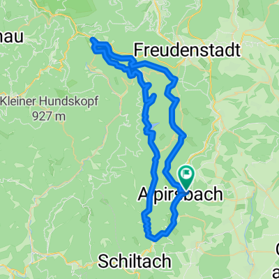
Alpirsbach zur Kniebishütte über Stausee zurück
A cycling route starting in Alpirsbach, Baden-Wurttemberg, Germany.
Overview
About this route
From Alpirsbach, the route goes over Schömberg to Kniebis, where you can make a stop at the managed Kniebishütte cabin for a rest. The return route goes via Zwieselberg and Reinerzau. From the reservoir, the public road was used. Alternatively, you can also return to Alpirsbach via the mountain.
Due to coarse gravel paths down to the reservoir, suitable only for MTB.
- -:--
- Duration
- 58.9 km
- Distance
- 697 m
- Ascent
- 697 m
- Descent
- ---
- Avg. speed
- ---
- Max. altitude

Route quality
Waytypes & surfaces along the route
Waytypes
Track
35.9 km
(61 %)
Quiet road
7.1 km
(12 %)
Surfaces
Paved
28.3 km
(48 %)
Unpaved
25.9 km
(44 %)
Gravel
24.2 km
(41 %)
Asphalt
22.4 km
(38 %)
Route highlights
Points of interest along the route
Point of interest after 24.5 km
Kniebishütte http://www.kniebishuette.de/
Continue with Bikemap
Use, edit, or download this cycling route
You would like to ride Alpirsbach zur Kniebishütte über Stausee zurück or customize it for your own trip? Here is what you can do with this Bikemap route:
Free features
- Save this route as favorite or in collections
- Copy & plan your own version of this route
- Sync your route with Garmin or Wahoo
Premium features
Free trial for 3 days, or one-time payment. More about Bikemap Premium.
- Navigate this route on iOS & Android
- Export a GPX / KML file of this route
- Create your custom printout (try it for free)
- Download this route for offline navigation
Discover more Premium features.
Get Bikemap PremiumFrom our community
Other popular routes starting in Alpirsbach
 Alpi-Loßburg-Wälde-Dornhan-Römlinsdorf-Alpi
- Distance
- 36.3 km
- Ascent
- 687 m
- Descent
- 671 m
- Location
- Alpirsbach, Baden-Wurttemberg, Germany
 Alpirsbach zum Marktplatz Freudenstadt und zurück
- Distance
- 39.7 km
- Ascent
- 622 m
- Descent
- 622 m
- Location
- Alpirsbach, Baden-Wurttemberg, Germany
 Alpirsbach zur Kniebishütte über Stausee zurück
- Distance
- 58.9 km
- Ascent
- 697 m
- Descent
- 697 m
- Location
- Alpirsbach, Baden-Wurttemberg, Germany
 Kinzigtal Schwarzwald
- Distance
- 54.7 km
- Ascent
- 1,015 m
- Descent
- 1,262 m
- Location
- Alpirsbach, Baden-Wurttemberg, Germany
 kleine Bettelmännle-Runde
- Distance
- 11.9 km
- Ascent
- 469 m
- Descent
- 471 m
- Location
- Alpirsbach, Baden-Wurttemberg, Germany
 Alpirsbach Rundtour 12.4.19
- Distance
- 34.6 km
- Ascent
- 566 m
- Descent
- 572 m
- Location
- Alpirsbach, Baden-Wurttemberg, Germany
 MTB_St.Roman
- Distance
- 60.6 km
- Ascent
- 947 m
- Descent
- 951 m
- Location
- Alpirsbach, Baden-Wurttemberg, Germany
 SURM - als KML-Datei
- Distance
- 148.1 km
- Ascent
- 2,007 m
- Descent
- 1,815 m
- Location
- Alpirsbach, Baden-Wurttemberg, Germany
Open it in the app