

20180822_140512.gpx
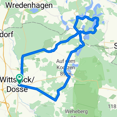
A cycling route starting in Wittstock, Brandenburg, Germany.
Overview
About this route
TAHUNA track
- -:--
- Duration
- 27.1 km
- Distance
- 110 m
- Ascent
- 132 m
- Descent
- ---
- Avg. speed
- ---
- Max. altitude
Route quality
Waytypes & surfaces along the route
Waytypes
Path
9.2 km
(34 %)
Quiet road
3.5 km
(13 %)
Surfaces
Paved
22.2 km
(82 %)
Asphalt
22.2 km
(82 %)
Undefined
4.9 km
(18 %)
Continue with Bikemap
Use, edit, or download this cycling route
You would like to ride 20180822_140512.gpx or customize it for your own trip? Here is what you can do with this Bikemap route:
Free features
- Save this route as favorite or in collections
- Copy & plan your own version of this route
- Sync your route with Garmin or Wahoo
Premium features
Free trial for 3 days, or one-time payment. More about Bikemap Premium.
- Navigate this route on iOS & Android
- Export a GPX / KML file of this route
- Create your custom printout (try it for free)
- Download this route for offline navigation
Discover more Premium features.
Get Bikemap PremiumFrom our community
Other popular routes starting in Wittstock
 Fischtour von H.Helfers
- Distance
- 53.3 km
- Ascent
- 194 m
- Descent
- 192 m
- Location
- Wittstock, Brandenburg, Germany
 Wittstock - Wolmirstedt 3 Tagestour
- Distance
- 215.5 km
- Ascent
- 268 m
- Descent
- 293 m
- Location
- Wittstock, Brandenburg, Germany
 Rundtour zum 1. Mai
- Distance
- 187.7 km
- Ascent
- 322 m
- Descent
- 317 m
- Location
- Wittstock, Brandenburg, Germany
 Klostertour v.H.Helfers
- Distance
- 53.3 km
- Ascent
- 162 m
- Descent
- 161 m
- Location
- Wittstock, Brandenburg, Germany
 Schloßtour von H.Helfers
- Distance
- 47.3 km
- Ascent
- 101 m
- Descent
- 99 m
- Location
- Wittstock, Brandenburg, Germany
 Brausebachtour von H.Helfers
- Distance
- 44.5 km
- Ascent
- 113 m
- Descent
- 111 m
- Location
- Wittstock, Brandenburg, Germany
 Anradeln der Prignitz am 12.April 2014
- Distance
- 64.7 km
- Ascent
- 177 m
- Descent
- 177 m
- Location
- Wittstock, Brandenburg, Germany
 Bischofs-& Dossetour Rundkurs
- Distance
- 223.8 km
- Ascent
- 227 m
- Descent
- 224 m
- Location
- Wittstock, Brandenburg, Germany
Open it in the app