

20160403_141949.gpx
A cycling route starting in Crinitz, Brandenburg, Germany.
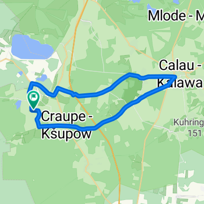
Overview
About this route
TAHUNA track
- -:--
- Duration
- 31.9 km
- Distance
- 78 m
- Ascent
- 124 m
- Descent
- ---
- Avg. speed
- ---
- Max. altitude
Continue with Bikemap
Use, edit, or download this cycling route
You would like to ride 20160403_141949.gpx or customize it for your own trip? Here is what you can do with this Bikemap route:
Free features
- Save this route as favorite or in collections
- Copy & plan your own version of this route
- Sync your route with Garmin or Wahoo
Premium features
Free trial for 3 days, or one-time payment. More about Bikemap Premium.
- Navigate this route on iOS & Android
- Export a GPX / KML file of this route
- Create your custom printout (try it for free)
- Download this route for offline navigation
Discover more Premium features.
Get Bikemap PremiumFrom our community
Other popular routes starting in Crinitz
 Schlabendorf- Lichtenau - Luckau
- Distance
- 43.6 km
- Ascent
- 32 m
- Descent
- 29 m
- Location
- Crinitz, Brandenburg, Germany
 Lindenplatz 6, Luckau nach Lindenplatz 10, Luckau
- Distance
- 20.6 km
- Ascent
- 74 m
- Descent
- 72 m
- Location
- Crinitz, Brandenburg, Germany
 Bornsdorf > Grünewalder Lauch
- Distance
- 41.4 km
- Ascent
- 227 m
- Descent
- 197 m
- Location
- Crinitz, Brandenburg, Germany
 Tour nach Calau und zurück
- Distance
- 20.2 km
- Ascent
- 102 m
- Descent
- 105 m
- Location
- Crinitz, Brandenburg, Germany
 33,2km.Fürtslich Drehna
- Distance
- 33.2 km
- Ascent
- 55 m
- Descent
- 56 m
- Location
- Crinitz, Brandenburg, Germany
 Draschemühle > Rietzneuendorf
- Distance
- 44.7 km
- Ascent
- 161 m
- Descent
- 174 m
- Location
- Crinitz, Brandenburg, Germany
 Spreewald
- Distance
- 61.9 km
- Ascent
- 258 m
- Descent
- 255 m
- Location
- Crinitz, Brandenburg, Germany
 Töpfermark Crinitz
- Distance
- 28.1 km
- Ascent
- 97 m
- Descent
- 100 m
- Location
- Crinitz, Brandenburg, Germany
Open it in the app