

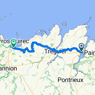
Lézardrieux - Le Légué - Guimgamp - 25 Août 18_YP.
A cycling route starting in Lézardrieux, Brittany Region, France.
Overview
About this route
Lézardrieux - Paimpol - Kérity - Ste Barbe – Plouézec - Lanloup – Tréveneuc - St Quay-Portrieux - Etables ( N.D. de l'Espérance ) - Binic – E.V. n°4 - Pordic – Viaduc de la Percée – St Eloy – Port-Martin – Ville Gaudin – Ville Agan – St Laurent – Le Légué – Pont du Gouët – Ville-Vivo – Le Sépulcre – Le Plessix – Trémuson – La Barricade – Châtelaudren – Plouagat – St Guignan – St Agathon – Guimgamp – Pabu - St Clet – Pontrieux – La Roche-Jagu – Pleudaniel – Kerantour – Pleumeur-Gautier - Lézardrieux.
- -:--
- Duration
- 133.6 km
- Distance
- 577 m
- Ascent
- 579 m
- Descent
- ---
- Avg. speed
- ---
- Max. altitude

Route quality
Waytypes & surfaces along the route
Waytypes
Road
30.7 km
(23 %)
Quiet road
18.7 km
(14 %)
Surfaces
Paved
72.1 km
(54 %)
Unpaved
1.3 km
(1 %)
Asphalt
72.1 km
(54 %)
Gravel
1.3 km
(1 %)
Undefined
60.1 km
(45 %)
Continue with Bikemap
Use, edit, or download this cycling route
You would like to ride Lézardrieux - Le Légué - Guimgamp - 25 Août 18_YP. or customize it for your own trip? Here is what you can do with this Bikemap route:
Free features
- Save this route as favorite or in collections
- Copy & plan your own version of this route
- Split it into stages to create a multi-day tour
- Sync your route with Garmin or Wahoo
Premium features
Free trial for 3 days, or one-time payment. More about Bikemap Premium.
- Navigate this route on iOS & Android
- Export a GPX / KML file of this route
- Create your custom printout (try it for free)
- Download this route for offline navigation
Discover more Premium features.
Get Bikemap PremiumFrom our community
Other popular routes starting in Lézardrieux
 Bréhec - Ménez-Bré - Plouaret - 22 Juillet 20.
- Distance
- 134.6 km
- Ascent
- 678 m
- Descent
- 678 m
- Location
- Lézardrieux, Brittany Region, France
 Chemin de Kerguistin nach Rue de Cruckin
- Distance
- 42.8 km
- Ascent
- 330 m
- Descent
- 420 m
- Location
- Lézardrieux, Brittany Region, France
 Lz - Bégard - Plouézec - Lz - 10 Sept. 17
- Distance
- 95.4 km
- Ascent
- 515 m
- Descent
- 514 m
- Location
- Lézardrieux, Brittany Region, France
 day four
- Distance
- 34.5 km
- Ascent
- 275 m
- Descent
- 284 m
- Location
- Lézardrieux, Brittany Region, France
 Boucle Goëlo - 27 Août 19 - Y et L.
- Distance
- 99.4 km
- Ascent
- 475 m
- Descent
- 477 m
- Location
- Lézardrieux, Brittany Region, France
 Monts d'Arrée et du Mené - Pl-Br-Pl - 20 & 21 Août 19.
- Distance
- 588.7 km
- Ascent
- 1,636 m
- Descent
- 1,636 m
- Location
- Lézardrieux, Brittany Region, France
 BRB 300 - Brevet Randonneurs Bretons
- Distance
- 305.5 km
- Ascent
- 1,199 m
- Descent
- 1,198 m
- Location
- Lézardrieux, Brittany Region, France
 Lz - Morbihan - Lz ( BPF 56 )
- Distance
- 495.2 km
- Ascent
- 942 m
- Descent
- 942 m
- Location
- Lézardrieux, Brittany Region, France
Open it in the app