

2018_08_25 Na vrchol
A cycling route starting in Příbram, Central Bohemia, Czechia.
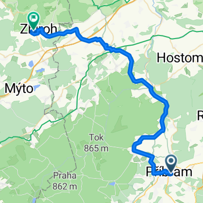
Overview
About this route
From Příbram through Jordan home with Mr. Čocha...
- -:--
- Duration
- 56.5 km
- Distance
- 696 m
- Ascent
- 802 m
- Descent
- ---
- Avg. speed
- ---
- Max. altitude

Route quality
Waytypes & surfaces along the route
Waytypes
Road
19.2 km
(34 %)
Quiet road
16.4 km
(29 %)
Surfaces
Paved
26 km
(46 %)
Unpaved
6.8 km
(12 %)
Asphalt
23.2 km
(41 %)
Gravel
2.8 km
(5 %)
Route highlights
Points of interest along the route

Photo after 4.1 km
Start...

Photo after 18.9 km
Panoramata...

Photo after 31.2 km
Pražské panorama...
Continue with Bikemap
Use, edit, or download this cycling route
You would like to ride 2018_08_25 Na vrchol or customize it for your own trip? Here is what you can do with this Bikemap route:
Free features
- Save this route as favorite or in collections
- Copy & plan your own version of this route
- Sync your route with Garmin or Wahoo
Premium features
Free trial for 3 days, or one-time payment. More about Bikemap Premium.
- Navigate this route on iOS & Android
- Export a GPX / KML file of this route
- Create your custom printout (try it for free)
- Download this route for offline navigation
Discover more Premium features.
Get Bikemap PremiumFrom our community
Other popular routes starting in Příbram
 Příbram, Obecnice, Padrťské rybníky, Nepomuk, Příbram
- Distance
- 48 km
- Ascent
- 616 m
- Descent
- 616 m
- Location
- Příbram, Central Bohemia, Czechia
 Brodská - Tok
- Distance
- 29.9 km
- Ascent
- 421 m
- Descent
- 472 m
- Location
- Příbram, Central Bohemia, Czechia
 Příbramský permoník České spořitelny 2009 - hlavní závod
- Distance
- 62.8 km
- Ascent
- 802 m
- Descent
- 793 m
- Location
- Příbram, Central Bohemia, Czechia
 Brdy - Tok - Jordán
- Distance
- 52 km
- Ascent
- 759 m
- Descent
- 757 m
- Location
- Příbram, Central Bohemia, Czechia
 Via Svata Hora Naar Dissidentenkamp
- Distance
- 11.1 km
- Ascent
- 197 m
- Descent
- 140 m
- Location
- Příbram, Central Bohemia, Czechia
 Příbram - Padrtě - Pilská - příbram
- Distance
- 44 km
- Ascent
- 540 m
- Descent
- 390 m
- Location
- Příbram, Central Bohemia, Czechia
 Příbram_úraz
- Distance
- 35 km
- Ascent
- 447 m
- Descent
- 455 m
- Location
- Příbram, Central Bohemia, Czechia
 CT D4 Pribram Zbiroh
- Distance
- 46.3 km
- Ascent
- 554 m
- Descent
- 523 m
- Location
- Příbram, Central Bohemia, Czechia
Open it in the app