

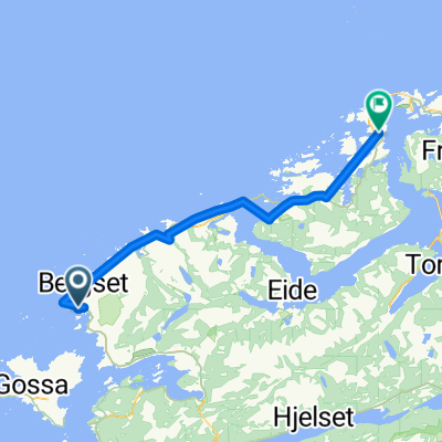
Norway 18: Malmefjorden-Lyngstad
A cycling route starting in Elnesvågen, Møre og Romsdal, Norway.
Overview
About this route
Eurovelo route number 1 up to the beginning of the Atlantic road. Then turn south to Akslia Camping.
- -:--
- Duration
- 62.9 km
- Distance
- 332 m
- Ascent
- 215 m
- Descent
- ---
- Avg. speed
- ---
- Max. altitude

Route photos


Route quality
Waytypes & surfaces along the route
Waytypes
Cycleway
21.4 km
(34 %)
Quiet road
3.1 km
(5 %)
Surfaces
Paved
40.3 km
(64 %)
Asphalt
40.3 km
(64 %)
Undefined
22.6 km
(36 %)
Continue with Bikemap
Use, edit, or download this cycling route
You would like to ride Norway 18: Malmefjorden-Lyngstad or customize it for your own trip? Here is what you can do with this Bikemap route:
Free features
- Save this route as favorite or in collections
- Copy & plan your own version of this route
- Sync your route with Garmin or Wahoo
Premium features
Free trial for 3 days, or one-time payment. More about Bikemap Premium.
- Navigate this route on iOS & Android
- Export a GPX / KML file of this route
- Create your custom printout (try it for free)
- Download this route for offline navigation
Discover more Premium features.
Get Bikemap PremiumFrom our community
Other popular routes starting in Elnesvågen
 EuroVelo 1 - Part 26
- Distance
- 108.7 km
- Ascent
- 949 m
- Descent
- 952 m
- Location
- Elnesvågen, Møre og Romsdal, Norway
 4 Hustadvika – Hollingsholm - Småge
- Distance
- 79.3 km
- Ascent
- 298 m
- Descent
- 297 m
- Location
- Elnesvågen, Møre og Romsdal, Norway
 041: Elnesvagen– Hollingen (DEVELOPED)
- Distance
- 36.7 km
- Ascent
- 375 m
- Descent
- 404 m
- Location
- Elnesvågen, Møre og Romsdal, Norway
 Elnesvågen - Farstad - Bud
- Distance
- 54.2 km
- Ascent
- 269 m
- Descent
- 269 m
- Location
- Elnesvågen, Møre og Romsdal, Norway
 les avions à vélo: Day 29 manque 1/2!
- Distance
- 51.5 km
- Ascent
- 418 m
- Descent
- 413 m
- Location
- Elnesvågen, Møre og Romsdal, Norway
 to the tunnel
- Distance
- 75.5 km
- Ascent
- 792 m
- Descent
- 778 m
- Location
- Elnesvågen, Møre og Romsdal, Norway
 2011 NOR - Atlanterhavsvegen
- Distance
- 53.4 km
- Ascent
- 260 m
- Descent
- 260 m
- Location
- Elnesvågen, Møre og Romsdal, Norway
 EuroVelo 1 - Part 10 - From Hustad to Fiskåbygd
- Distance
- 248.9 km
- Ascent
- 755 m
- Descent
- 748 m
- Location
- Elnesvågen, Møre og Romsdal, Norway
Open it in the app