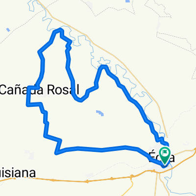
11 ETAPA CARRETERA CCCS2018
A cycling route starting in Écija, Andalusia, Spain.
Overview
About this route
ECIJA - CERRO PEREA - LOS ALGARBES - LA GUIJARROSA - SAN SEBASTIAN DE LOS BALLESTEROS - LA VICTORIA - ALDEA QUINTANA - LA CARLOTA - FUENCUBIERTA - LA VENTILLA - FUENTE PALMERA - CAÑADA DEL RABADAN - ECIJA
- -:--
- Duration
- 87.5 km
- Distance
- 410 m
- Ascent
- 409 m
- Descent
- ---
- Avg. speed
- ---
- Avg. speed
Route quality
Waytypes & surfaces along the route
Waytypes
Road
34.1 km
(39 %)
Busy road
17.5 km
(20 %)
Surfaces
Paved
15.7 km
(18 %)
Asphalt
15.7 km
(18 %)
Undefined
71.9 km
(82 %)
Continue with Bikemap
Use, edit, or download this cycling route
You would like to ride 11 ETAPA CARRETERA CCCS2018 or customize it for your own trip? Here is what you can do with this Bikemap route:
Free features
- Save this route as favorite or in collections
- Copy & plan your own version of this route
- Sync your route with Garmin or Wahoo
Premium features
Free trial for 3 days, or one-time payment. More about Bikemap Premium.
- Navigate this route on iOS & Android
- Export a GPX / KML file of this route
- Create your custom printout (try it for free)
- Download this route for offline navigation
Discover more Premium features.
Get Bikemap PremiumFrom our community
Other popular routes starting in Écija
- 12 CARRETERA CCCS2018
- Distance
- 92.5 km
- Ascent
- 803 m
- Descent
- 802 m
- Location
- Écija, Andalusia, Spain
- Vereda de Santaella - Turullote - Vereda de la Trocha
- Distance
- 35.6 km
- Ascent
- 291 m
- Descent
- 293 m
- Location
- Écija, Andalusia, Spain
- CX 26 MAR 2016
- Distance
- 61.8 km
- Ascent
- 307 m
- Descent
- 304 m
- Location
- Écija, Andalusia, Spain
- Ruta del lagarto 2016
- Distance
- 73.2 km
- Ascent
- 306 m
- Descent
- 306 m
- Location
- Écija, Andalusia, Spain
- 3 CARRETERA CCCS2017
- Distance
- 96.9 km
- Ascent
- 493 m
- Descent
- 495 m
- Location
- Écija, Andalusia, Spain
- GALLAPE Torreon Medieval
- Distance
- 41.4 km
- Ascent
- 249 m
- Descent
- 249 m
- Location
- Écija, Andalusia, Spain
- 7 ETAPA BTT CCCS2018 (PREVIA RUTA DEL CALOR)
- Distance
- 81.6 km
- Ascent
- 326 m
- Descent
- 335 m
- Location
- Écija, Andalusia, Spain
- 13 BTT CCCS'17
- Distance
- 75.2 km
- Ascent
- 439 m
- Descent
- 449 m
- Location
- Écija, Andalusia, Spain