

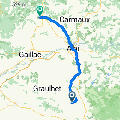
Sortie rando c20 cyclorando 13/10
A cycling route starting in Lautrec, Occitanie, France.
Overview
About this route
- -:--
- Duration
- 60.6 km
- Distance
- 467 m
- Ascent
- 454 m
- Descent
- ---
- Avg. speed
- ---
- Max. altitude

Route quality
Waytypes & surfaces along the route
Waytypes
Quiet road
38.1 km
(63 %)
Road
16.3 km
(27 %)
Surfaces
Paved
0.6 km
(1 %)
Unpaved
0.6 km
(1 %)
Asphalt
0.6 km
(1 %)
Gravel
0.6 km
(1 %)
Undefined
59.3 km
(98 %)
Continue with Bikemap
Use, edit, or download this cycling route
You would like to ride Sortie rando c20 cyclorando 13/10 or customize it for your own trip? Here is what you can do with this Bikemap route:
Free features
- Save this route as favorite or in collections
- Copy & plan your own version of this route
- Sync your route with Garmin or Wahoo
Premium features
Free trial for 3 days, or one-time payment. More about Bikemap Premium.
- Navigate this route on iOS & Android
- Export a GPX / KML file of this route
- Create your custom printout (try it for free)
- Download this route for offline navigation
Discover more Premium features.
Get Bikemap PremiumFrom our community
Other popular routes starting in Lautrec
 Lautrec - Cordes-sur-Ciel
- Distance
- 60.5 km
- Ascent
- 660 m
- Descent
- 636 m
- Location
- Lautrec, Occitanie, France
 Lautrec à Rue de la Caussade, Lautrec
- Distance
- 3.3 km
- Ascent
- 95 m
- Descent
- 59 m
- Location
- Lautrec, Occitanie, France
 Itinéraire à partir de 9 Hameau de la Jonquière, Castres
- Distance
- 5.5 km
- Ascent
- 40 m
- Descent
- 75 m
- Location
- Lautrec, Occitanie, France
 Sortie balade c20 cyclorando 13/10
- Distance
- 47.9 km
- Ascent
- 442 m
- Descent
- 439 m
- Location
- Lautrec, Occitanie, France
 lautrec - lavaur
- Distance
- 139.5 km
- Ascent
- 1,146 m
- Descent
- 1,297 m
- Location
- Lautrec, Occitanie, France
 Relaxed route in Castres
- Distance
- 19 km
- Ascent
- 292 m
- Descent
- 353 m
- Location
- Lautrec, Occitanie, France
 Sortie rando c20 cyclorando 13/10
- Distance
- 60.6 km
- Ascent
- 467 m
- Descent
- 454 m
- Location
- Lautrec, Occitanie, France
 venes Albi voie verte :)
- Distance
- 25.6 km
- Ascent
- 94 m
- Descent
- 200 m
- Location
- Lautrec, Occitanie, France
Open it in the app