

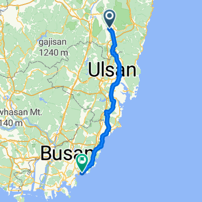
South Korea east coast tour 2018
Gyeongju - Gyeongjeon
A cycling route starting in Gyeongju, Gyeongsangbuk-do, South Korea.
Overview
About this route
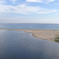
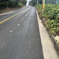
A very nice and quiet road to ride on through small villages and countryside for the first 48 kilometres. At Pilhwa-Ri, the crossroads between road 930 and road 7, we took north to follow road 7 contrary to what is shown on the map. Bad choice, a lot of traffic. Once back on the coast, a bike line is to be found again. The views are breathtaking, the quiet fishing villages' homes are artfully painted.
- -:--
- Duration
- 90.2 km
- Distance
- 335 m
- Ascent
- 347 m
- Descent
- ---
- Avg. speed
- ---
- Max. altitude

Part of
7 stages
Route quality
Waytypes & surfaces along the route
Waytypes
Busy road
34.9 km
(39 %)
Road
22.2 km
(25 %)
Surfaces
Paved
15.3 km
(17 %)
Asphalt
14.3 km
(16 %)
Concrete
0.6 km
(<1 %)
Continue with Bikemap
Use, edit, or download this cycling route
You would like to ride Gyeongju - Gyeongjeon or customize it for your own trip? Here is what you can do with this Bikemap route:
Free features
- Save this route as favorite or in collections
- Copy & plan your own version of this route
- Split it into stages to create a multi-day tour
- Sync your route with Garmin or Wahoo
Premium features
Free trial for 3 days, or one-time payment. More about Bikemap Premium.
- Navigate this route on iOS & Android
- Export a GPX / KML file of this route
- Create your custom printout (try it for free)
- Download this route for offline navigation
Discover more Premium features.
Get Bikemap PremiumFrom our community
Other popular routes starting in Gyeongju
 경주(낭산의 신비를 찾아서)
- Distance
- 14.4 km
- Ascent
- 128 m
- Descent
- 111 m
- Location
- Gyeongju, Gyeongsangbuk-do, South Korea
 ipsil
ipsil- Distance
- 8 km
- Ascent
- 46 m
- Descent
- 60 m
- Location
- Gyeongju, Gyeongsangbuk-do, South Korea
 경주 자전거코스
- Distance
- 32.4 km
- Ascent
- 932 m
- Descent
- 932 m
- Location
- Gyeongju, Gyeongsangbuk-do, South Korea
 Gyeongju - Gyeongjeon
- Distance
- 90.2 km
- Ascent
- 335 m
- Descent
- 347 m
- Location
- Gyeongju, Gyeongsangbuk-do, South Korea
 Gujeong-dong 483-15, Gyeongju to U 1(il)-dong 1151-14
- Distance
- 90.9 km
- Ascent
- 1,146 m
- Descent
- 1,242 m
- Location
- Gyeongju, Gyeongsangbuk-do, South Korea
 성건동, 경주시에서 약성리, 포항시까지
- Distance
- 46.9 km
- Ascent
- 330 m
- Descent
- 369 m
- Location
- Gyeongju, Gyeongsangbuk-do, South Korea
![Ph0]에서 경로북군동 11-1](https://media.bikemap.net/routes/17321743/gallery/thumbs/16e4758b-722a-401a-b822-211a2e7d452b.jpg.208x208_q80_crop.jpg) Ph0]에서 경로북군동 11-1
Ph0]에서 경로북군동 11-1- Distance
- 729.6 km
- Ascent
- 26,913 m
- Descent
- 26,991 m
- Location
- Gyeongju, Gyeongsangbuk-do, South Korea
 경주 KTX-24블루원고개-35불국로고개-55기림로고개-75방산로고개-103숙소-120추령-남산
- Distance
- 143.3 km
- Ascent
- 2,422 m
- Descent
- 2,454 m
- Location
- Gyeongju, Gyeongsangbuk-do, South Korea
Open it in the app