

Wbk- Leitersweiler
A cycling route starting in Hangard, Saarland, Germany.
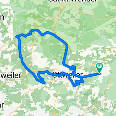
Overview
About this route
Initially through the Ostertal, from Oberkirchen uphill, towards Leitersweiler, there again uphill, Urweiler etc. beautiful quiet route
- -:--
- Duration
- 49.6 km
- Distance
- 377 m
- Ascent
- 377 m
- Descent
- ---
- Avg. speed
- ---
- Max. altitude
Route quality
Waytypes & surfaces along the route
Waytypes
Quiet road
5.5 km
(11 %)
Path
3 km
(6 %)
Surfaces
Paved
34.7 km
(70 %)
Unpaved
2 km
(4 %)
Asphalt
33.2 km
(67 %)
Paved (undefined)
1.5 km
(3 %)
Continue with Bikemap
Use, edit, or download this cycling route
You would like to ride Wbk- Leitersweiler or customize it for your own trip? Here is what you can do with this Bikemap route:
Free features
- Save this route as favorite or in collections
- Copy & plan your own version of this route
- Sync your route with Garmin or Wahoo
Premium features
Free trial for 3 days, or one-time payment. More about Bikemap Premium.
- Navigate this route on iOS & Android
- Export a GPX / KML file of this route
- Create your custom printout (try it for free)
- Download this route for offline navigation
Discover more Premium features.
Get Bikemap PremiumFrom our community
Other popular routes starting in Hangard
 Für Mountenbiker
- Distance
- 10.8 km
- Ascent
- 369 m
- Descent
- 368 m
- Location
- Hangard, Saarland, Germany
 Wiebelskirchen - Wellesweiler MTB
- Distance
- 21.9 km
- Ascent
- 255 m
- Descent
- 255 m
- Location
- Hangard, Saarland, Germany
 Homburg über den Kohlhof
- Distance
- 34.8 km
- Ascent
- 314 m
- Descent
- 315 m
- Location
- Hangard, Saarland, Germany
 Paulengrund
- Distance
- 50.4 km
- Ascent
- 425 m
- Descent
- 428 m
- Location
- Hangard, Saarland, Germany
 Friedhofstraße 11, Neunkirchen nach Friedhofstraße 14, Neunkirchen
- Distance
- 36.7 km
- Ascent
- 1,195 m
- Descent
- 1,269 m
- Location
- Hangard, Saarland, Germany
 Leichtes Bergtraining
- Distance
- 43.6 km
- Ascent
- 714 m
- Descent
- 704 m
- Location
- Hangard, Saarland, Germany
 Ottweiler Radweg 4
- Distance
- 28.3 km
- Ascent
- 429 m
- Descent
- 429 m
- Location
- Hangard, Saarland, Germany
 Ottweiler Radweg 1
- Distance
- 30.6 km
- Ascent
- 428 m
- Descent
- 428 m
- Location
- Hangard, Saarland, Germany
Open it in the app