

Wien - Mariazell - Neusiedler See (2018)
Unterwaltersdorf - Podersdorf
A cycling route starting in Mitterndorf an der Fischa, Lower Austria, Austria.
Overview
About this route
1
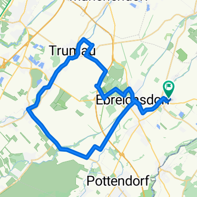
Wien - Mariazell - Neusiedler See, Tag 6/7
- -:--
- Duration
- 56.6 km
- Distance
- 252 m
- Ascent
- 325 m
- Descent
- ---
- Avg. speed
- ---
- Max. altitude
Thurli
created this 7 years ago
Part of
Route quality
Waytypes & surfaces along the route
Waytypes
Track
22.1 km
39 %
Quiet road
16.4 km
29 %
Surfaces
Paved
35.6 km
(63 %)
Unpaved
15.3 km
(27 %)
Asphalt
35.6 km
63 %
Loose gravel
7.4 km
13 %
Continue with Bikemap
Use, edit, or download this cycling route
You would like to ride Unterwaltersdorf - Podersdorf or customize it for your own trip? Here is what you can do with this Bikemap route:
Free features
- Save this route as favorite or in collections
- Copy & plan your own version of this route
- Sync your route with Garmin or Wahoo
Premium features
Free trial for 3 days, or one-time payment. More about Bikemap Premium.
- Navigate this route on iOS & Android
- Export a GPX / KML file of this route
- Create your custom printout (try it for free)
- Download this route for offline navigation
Discover more Premium features.
Get Bikemap PremiumFrom our community
Other popular routes starting in Mitterndorf an der Fischa
- Schloßgarten 3, Unterwaltersdorf nach Schloßgarten 3, Unterwaltersdorf0
- 35.1 km
- 162 m
- 163 m
- Mitterndorf an der Fischa, Lower Austria, Austria
- Obere Ortsstraße nach Obere Ortsstraße0
- 52.1 km
- 460 m
- 459 m
- Mitterndorf an der Fischa, Lower Austria, Austria
- Obere Ortsstraße nach Obere Ortsstraße0
- 23.4 km
- 159 m
- 215 m
- Mitterndorf an der Fischa, Lower Austria, Austria
- Und Mmünchendorf Achau Laxenburg Vösendorf Wien23 Schwechat Himberg Dbergassing Uwd0
- 72.1 km
- 287 m
- 284 m
- Mitterndorf an der Fischa, Lower Austria, Austria


Open it in the app