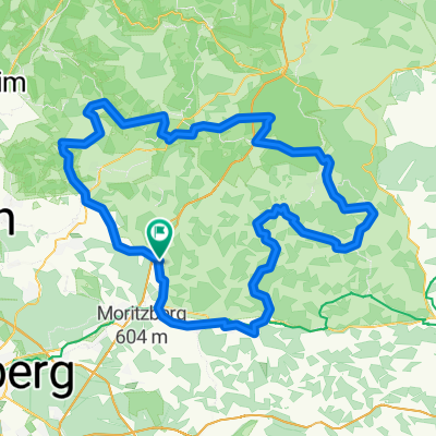
MFC 2010, Teuferla's Tour rund um Schnaittach - Strecke 3
A cycling route starting in Schnaittach, Bavaria, Germany.
Overview
About this route
I initially created the tour using Google Earth with the help of a bitmap overlay of the route map from RC Schnaittachtal.
In the meantime, I have redrawn the route. Here and there, I'm not sure if we actually rode it exactly like that.
I spared myself the long tour. I didn’t want to tackle the additional 500 meters of elevation, especially because there was constant headwind during the previous 40 km. The tour rightly earns its name. Devilish, devilish.
On some parts of the route, I would have liked better signage. Since it was quite lonely overall, you couldn’t necessarily follow other participants for guidance. And when you haven’t seen a red sign for a long time, you start wondering if you’re still on the right track.
Otherwise, it was as usual: good refreshments, friendly people. They can’t do anything about the weather. Wearing winter gloves in mid-May… brrrrr…
- -:--
- Duration
- 123.3 km
- Distance
- 658 m
- Ascent
- 658 m
- Descent
- ---
- Avg. speed
- ---
- Max. altitude
Route quality
Waytypes & surfaces along the route
Waytypes
Road
40.7 km
(33 %)
Quiet road
33.3 km
(27 %)
Surfaces
Paved
77.7 km
(63 %)
Unpaved
3.7 km
(3 %)
Asphalt
75.2 km
(61 %)
Gravel
3.7 km
(3 %)
Route highlights
Points of interest along the route
Point of interest after 19.7 km
Kontrollstelle 1
Point of interest after 45.8 km
Kontrollstelle 2
Point of interest after 86.3 km
Kontrollstelle 3
Continue with Bikemap
Use, edit, or download this cycling route
You would like to ride MFC 2010, Teuferla's Tour rund um Schnaittach - Strecke 3 or customize it for your own trip? Here is what you can do with this Bikemap route:
Free features
- Save this route as favorite or in collections
- Copy & plan your own version of this route
- Split it into stages to create a multi-day tour
- Sync your route with Garmin or Wahoo
Premium features
Free trial for 3 days, or one-time payment. More about Bikemap Premium.
- Navigate this route on iOS & Android
- Export a GPX / KML file of this route
- Create your custom printout (try it for free)
- Download this route for offline navigation
Discover more Premium features.
Get Bikemap PremiumFrom our community
Other popular routes starting in Schnaittach
Quer Feld ein nach Spies- Distance
- 22.8 km
- Ascent
- 334 m
- Descent
- 327 m
- Location
- Schnaittach, Bavaria, Germany
Schnaittach-Vorra-Schnaittach- Distance
- 39.6 km
- Ascent
- 785 m
- Descent
- 906 m
- Location
- Schnaittach, Bavaria, Germany
Fritz-Schnelbögl-Straße 14, Schnaittach nach Amag-Hilpert-Straße 20, Pegnitz- Distance
- 34.5 km
- Ascent
- 415 m
- Descent
- 345 m
- Location
- Schnaittach, Bavaria, Germany
Rollhofen - Dehnberg - Lauf- Distance
- 9.3 km
- Ascent
- 168 m
- Descent
- 181 m
- Location
- Schnaittach, Bavaria, Germany
MFC 2010, Teuferla's Tour rund um Schnaittach - Strecke 3- Distance
- 123.3 km
- Ascent
- 658 m
- Descent
- 658 m
- Location
- Schnaittach, Bavaria, Germany
W - Schnaittach-Lochhof- Distance
- 4.8 km
- Ascent
- 111 m
- Descent
- 115 m
- Location
- Schnaittach, Bavaria, Germany
20. Mittelfrankencup 2012 Ausfahrt 03 am 20.05.2012 in Schnaittach- Distance
- 153 km
- Ascent
- 985 m
- Descent
- 985 m
- Location
- Schnaittach, Bavaria, Germany
Frankenalp 3- Distance
- 23.1 km
- Ascent
- 371 m
- Descent
- 364 m
- Location
- Schnaittach, Bavaria, Germany
Open it in the app

