

Panicale area - flat
A cycling route starting in Tavernelle, Umbria, Italy.
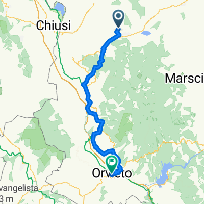
Overview
About this route
Villa Rey to Castiglione Della Valle via Tavernelle
- -:--
- Duration
- 46.9 km
- Distance
- 198 m
- Ascent
- 197 m
- Descent
- ---
- Avg. speed
- ---
- Max. altitude
Route quality
Waytypes & surfaces along the route
Waytypes
Quiet road
9.8 km
(21 %)
Road
4.7 km
(10 %)
Surfaces
Paved
29.5 km
(63 %)
Unpaved
5.6 km
(12 %)
Asphalt
25.3 km
(54 %)
Unpaved (undefined)
4.7 km
(10 %)
Continue with Bikemap
Use, edit, or download this cycling route
You would like to ride Panicale area - flat or customize it for your own trip? Here is what you can do with this Bikemap route:
Free features
- Save this route as favorite or in collections
- Copy & plan your own version of this route
- Sync your route with Garmin or Wahoo
Premium features
Free trial for 3 days, or one-time payment. More about Bikemap Premium.
- Navigate this route on iOS & Android
- Export a GPX / KML file of this route
- Create your custom printout (try it for free)
- Download this route for offline navigation
Discover more Premium features.
Get Bikemap PremiumFrom our community
Other popular routes starting in Tavernelle
 Rundtour Villa Rey Panicale - Paciano 19
- Distance
- 19 km
- Ascent
- 375 m
- Descent
- 391 m
- Location
- Tavernelle, Umbria, Italy
 Greppolischieto_Montarale
- Distance
- 25.7 km
- Ascent
- 741 m
- Descent
- 734 m
- Location
- Tavernelle, Umbria, Italy
 seconda
- Distance
- 76.5 km
- Ascent
- 578 m
- Descent
- 582 m
- Location
- Tavernelle, Umbria, Italy
 terza
terza- Distance
- 71.8 km
- Ascent
- 252 m
- Descent
- 256 m
- Location
- Tavernelle, Umbria, Italy
 R2_E1_L1_57_835_Villa_Orvieto
- Distance
- 57.4 km
- Ascent
- 1,038 m
- Descent
- 1,020 m
- Location
- Tavernelle, Umbria, Italy
 Rundtour - Tavernelle - Castiglion Fosco 19
- Distance
- 18.7 km
- Ascent
- 448 m
- Descent
- 449 m
- Location
- Tavernelle, Umbria, Italy
 I Umbrien 1
- Distance
- 136.6 km
- Ascent
- 1,191 m
- Descent
- 1,188 m
- Location
- Tavernelle, Umbria, Italy
 I Umbrien 2
- Distance
- 111.2 km
- Ascent
- 1,196 m
- Descent
- 1,199 m
- Location
- Tavernelle, Umbria, Italy
Open it in the app