

explorare buhalnita
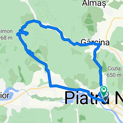
A cycling route starting in Piatra Neamţ, Neamț County, Romania.
Overview
About this route
Cuiejdi - Buhalniţa, Buhalniţa/Ruginesti - Pângărăcior crossings.
Easy crossing towards Buhalniţa, maximum 20 minutes of pushing the bike along a forest work track. Hunting cabin at the highest point.
The climb to Feţei peak or Obcinii peak is very steep on both sides, more than an hour of pushing. Steep descent on a forest track down to the source of Pângărăcior, then 10 km of downhill forest road.
- -:--
- Duration
- 63 km
- Distance
- 1,343 m
- Ascent
- 1,371 m
- Descent
- ---
- Avg. speed
- ---
- Max. altitude

Route highlights
Points of interest along the route

Photo after 34.1 km
Vf. Obcinii

Point of interest after 39.5 km
Intersecţie Obârşia Pângărăciorului. Troiţă. Izvor.

Point of interest after 42.4 km
Forestier spre Gârcina.
Continue with Bikemap
Use, edit, or download this cycling route
You would like to ride explorare buhalnita or customize it for your own trip? Here is what you can do with this Bikemap route:
Free features
- Save this route as favorite or in collections
- Copy & plan your own version of this route
- Sync your route with Garmin or Wahoo
Premium features
Free trial for 3 days, or one-time payment. More about Bikemap Premium.
- Navigate this route on iOS & Android
- Export a GPX / KML file of this route
- Create your custom printout (try it for free)
- Download this route for offline navigation
Discover more Premium features.
Get Bikemap PremiumFrom our community
Other popular routes starting in Piatra Neamţ
 Vf. Prihodiștea route
- Distance
- 18.7 km
- Ascent
- 699 m
- Descent
- 702 m
- Location
- Piatra Neamţ, Neamț County, Romania
 offroad 1.Nov.09
- Distance
- 48.6 km
- Ascent
- 1,266 m
- Descent
- 1,265 m
- Location
- Piatra Neamţ, Neamț County, Romania
 ride through Piatra Neamţ
- Distance
- 13.3 km
- Ascent
- 635 m
- Descent
- 635 m
- Location
- Piatra Neamţ, Neamț County, Romania
 Piatra Neamt - Vădurele - Izvorul lui Fănică - Agârcia - Bâtca Doamnei
- Distance
- 36.2 km
- Ascent
- 1,072 m
- Descent
- 1,066 m
- Location
- Piatra Neamţ, Neamț County, Romania
 traseul lung de crosa Piatra Neamț
- Distance
- 18.8 km
- Ascent
- 801 m
- Descent
- 812 m
- Location
- Piatra Neamţ, Neamț County, Romania
 explorare bistrita
- Distance
- 31.2 km
- Ascent
- 489 m
- Descent
- 482 m
- Location
- Piatra Neamţ, Neamț County, Romania
 Tur Piatra Neamț - Cozla - Valea Viei
- Distance
- 9.9 km
- Ascent
- 344 m
- Descent
- 341 m
- Location
- Piatra Neamţ, Neamț County, Romania
 Bahrin 5 Aprilie
- Distance
- 27.8 km
- Ascent
- 687 m
- Descent
- 698 m
- Location
- Piatra Neamţ, Neamț County, Romania
Open it in the app