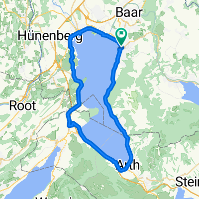
Zugerberg Up+Down
A cycling route starting in Zug, Canton of Zug, Switzerland.
Overview
About this route
good old local trail
- -:--
- Duration
- 15.2 km
- Distance
- 595 m
- Ascent
- 595 m
- Descent
- ---
- Avg. speed
- ---
- Max. altitude
Continue with Bikemap
Use, edit, or download this cycling route
You would like to ride Zugerberg Up+Down or customize it for your own trip? Here is what you can do with this Bikemap route:
Free features
- Save this route as favorite or in collections
- Copy & plan your own version of this route
- Sync your route with Garmin or Wahoo
Premium features
Free trial for 3 days, or one-time payment. More about Bikemap Premium.
- Navigate this route on iOS & Android
- Export a GPX / KML file of this route
- Create your custom printout (try it for free)
- Download this route for offline navigation
Discover more Premium features.
Get Bikemap PremiumFrom our community
Other popular routes starting in Zug
Von Zug bis Luzern- Distance
- 30.5 km
- Ascent
- 200 m
- Descent
- 180 m
- Location
- Zug, Canton of Zug, Switzerland
Zugerberg Up+Down- Distance
- 15.2 km
- Ascent
- 595 m
- Descent
- 595 m
- Location
- Zug, Canton of Zug, Switzerland
Sihltal-Zimmerberg-Sihlmatt- Distance
- 31.6 km
- Ascent
- 988 m
- Descent
- 982 m
- Location
- Zug, Canton of Zug, Switzerland
Lengthy Sunday Route In Zug- Distance
- 13.8 km
- Ascent
- 769 m
- Descent
- 770 m
- Location
- Zug, Canton of Zug, Switzerland
Fuchsloch, Oberwil b. Zug nach Fuchsloch, Oberwil b. Zug- Distance
- 24 km
- Ascent
- 607 m
- Descent
- 608 m
- Location
- Zug, Canton of Zug, Switzerland
Trainingsroute Zug- Distance
- 17.9 km
- Ascent
- 576 m
- Descent
- 576 m
- Location
- Zug, Canton of Zug, Switzerland
Zug-Trin- Distance
- 159.9 km
- Ascent
- 2,310 m
- Descent
- 1,856 m
- Location
- Zug, Canton of Zug, Switzerland
Wildspitz Mit Downhill Ürzlebode- Distance
- 46.3 km
- Ascent
- 1,199 m
- Descent
- 1,196 m
- Location
- Zug, Canton of Zug, Switzerland
Open it in the app

