

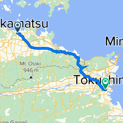
Gosikidai see line
A cycling route starting in Takamatsu, Kagawa, Japan.
Overview
About this route
- -:--
- Duration
- 39.5 km
- Distance
- 223 m
- Ascent
- 219 m
- Descent
- ---
- Avg. speed
- ---
- Max. altitude

Route quality
Waytypes & surfaces along the route
Waytypes
Quiet road
13 km
(33 %)
Cycleway
2.8 km
(7 %)
Continue with Bikemap
Use, edit, or download this cycling route
You would like to ride Gosikidai see line or customize it for your own trip? Here is what you can do with this Bikemap route:
Free features
- Save this route as favorite or in collections
- Copy & plan your own version of this route
- Sync your route with Garmin or Wahoo
Premium features
Free trial for 3 days, or one-time payment. More about Bikemap Premium.
- Navigate this route on iOS & Android
- Export a GPX / KML file of this route
- Create your custom printout (try it for free)
- Download this route for offline navigation
Discover more Premium features.
Get Bikemap PremiumFrom our community
Other popular routes starting in Takamatsu
 Takamatsu - Marugame 30km
- Distance
- 29.5 km
- Ascent
- 54 m
- Descent
- 52 m
- Location
- Takamatsu, Kagawa, Japan
 Japon 2014 - île de Shikoku
- Distance
- 224.1 km
- Ascent
- 1,281 m
- Descent
- 1,239 m
- Location
- Takamatsu, Kagawa, Japan
 8, Takamatsu to 637-2, Kotohira
- Distance
- 34.8 km
- Ascent
- 29 m
- Descent
- 8 m
- Location
- Takamatsu, Kagawa, Japan
 高松Takamatsu-德島Tokushima P-D1
- Distance
- 69.6 km
- Ascent
- 550 m
- Descent
- 553 m
- Location
- Takamatsu, Kagawa, Japan
 Shikoku trip day1
- Distance
- 32.9 km
- Ascent
- 104 m
- Descent
- 266 m
- Location
- Takamatsu, Kagawa, Japan
 高松ルート
高松ルート- Distance
- 88.4 km
- Ascent
- 1,103 m
- Descent
- 1,100 m
- Location
- Takamatsu, Kagawa, Japan
 Takamatsu-Tokushima
- Distance
- 74.5 km
- Ascent
- 417 m
- Descent
- 419 m
- Location
- Takamatsu, Kagawa, Japan
 180331_丸龜城
- Distance
- 49.5 km
- Ascent
- 1,164 m
- Descent
- 1,147 m
- Location
- Takamatsu, Kagawa, Japan
Open it in the app