

Chabaně-Stupava-Holý kopec 25/4/2010
A cycling route starting in Uherské Hradiště, Zlín, Czechia.
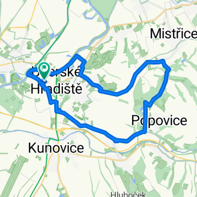
Overview
About this route
An unexpectedly nice route, not very busy.
- -:--
- Duration
- 54.4 km
- Distance
- 561 m
- Ascent
- 564 m
- Descent
- ---
- Avg. speed
- ---
- Max. altitude

Route quality
Waytypes & surfaces along the route
Waytypes
Track
22.3 km
(41 %)
Quiet road
13.1 km
(24 %)
Surfaces
Paved
40.3 km
(74 %)
Unpaved
8.2 km
(15 %)
Asphalt
31 km
(57 %)
Paved (undefined)
7.1 km
(13 %)
Route highlights
Points of interest along the route

Point of interest after 0.2 km
cesta z města

Point of interest after 6.3 km
Před Velehradem

Point of interest after 9.9 km
Velehrad

Point of interest after 10.1 km

Point of interest after 10.2 km
pole nad Velehradem

Point of interest after 13.1 km
Chabaně

Point of interest after 14.5 km
Břestek- pod skalou

Point of interest after 14.5 km
hospoda pod skalou

Point of interest after 18.4 km
drobný stoupák k Zikmundovu

Point of interest after 18.8 km
rozcestník

Point of interest after 21.3 km
Zikmundov

Point of interest after 23.6 km
Staré Hutě

Point of interest after 25.6 km
Stupava

Point of interest after 26.8 km
Stupava

Point of interest after 27.6 km
les nad Stupavou

Point of interest after 28.2 km
v dálce Buchlov

Point of interest after 29.8 km
cesta k Holému kopci

Point of interest after 30.6 km

Point of interest after 30.7 km
okruh okolo Holého kopce

Point of interest after 33.9 km
Na pile

Point of interest after 37.5 km
občerstvovací stanice

Point of interest after 48.2 km
Kostelanský most

Point of interest after 48.3 km
řeka Morava

Point of interest after 51.4 km
obchvat
Continue with Bikemap
Use, edit, or download this cycling route
You would like to ride Chabaně-Stupava-Holý kopec 25/4/2010 or customize it for your own trip? Here is what you can do with this Bikemap route:
Free features
- Save this route as favorite or in collections
- Copy & plan your own version of this route
- Sync your route with Garmin or Wahoo
Premium features
Free trial for 3 days, or one-time payment. More about Bikemap Premium.
- Navigate this route on iOS & Android
- Export a GPX / KML file of this route
- Create your custom printout (try it for free)
- Download this route for offline navigation
Discover more Premium features.
Get Bikemap PremiumFrom our community
Other popular routes starting in Uherské Hradiště
 Kosiky-Bunc-Brdo-Vlcak a pak na Salas a zpet
- Distance
- 50.5 km
- Ascent
- 553 m
- Descent
- 519 m
- Location
- Uherské Hradiště, Zlín, Czechia
 Salaš-Bunč-Vlčák-Salaš 18/4/2010
- Distance
- 47.9 km
- Ascent
- 497 m
- Descent
- 499 m
- Location
- Uherské Hradiště, Zlín, Czechia
 Chabaně-Stupava-Holý kopec 25/4/2010
- Distance
- 54.4 km
- Ascent
- 561 m
- Descent
- 564 m
- Location
- Uherské Hradiště, Zlín, Czechia
 Nedělní výšlap pianko po rovince :-) spíš giro de pifko !!!
- Distance
- 57.6 km
- Ascent
- 242 m
- Descent
- 244 m
- Location
- Uherské Hradiště, Zlín, Czechia
 czechy kromeriz 38km
- Distance
- 38.1 km
- Ascent
- 99 m
- Descent
- 77 m
- Location
- Uherské Hradiště, Zlín, Czechia
 Na Bunč přes Košíky a zpět
- Distance
- 51.3 km
- Ascent
- 563 m
- Descent
- 561 m
- Location
- Uherské Hradiště, Zlín, Czechia
 Uherské Hradiště - Komárov - Karlovice - Lhota
- Distance
- 52 km
- Ascent
- 686 m
- Descent
- 683 m
- Location
- Uherské Hradiště, Zlín, Czechia
 Nedělní vyjížďka kolem Hradiště
- Distance
- 19.5 km
- Ascent
- 181 m
- Descent
- 182 m
- Location
- Uherské Hradiště, Zlín, Czechia
Open it in the app