Spaziergang-10.09.2025
- 1.6 km
- 20 m
- 23 m
- Freiberg, Saxony, Germany
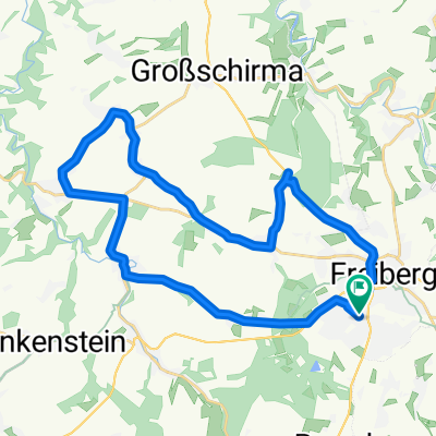
A cycling route starting in Freiberg, Saxony, Germany.
Overview
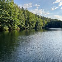
Scenic route in the Erzgebirge mountains. Occasionally demanding climbs, passing by the Neunzehnhainer dam. Very nicely situated. Some places to stop for refreshments along the way.
created this 15 years ago
Route quality
Track
29.2 km
(63 %)
Quiet road
8.3 km
(18 %)
Paved
21.8 km
(47 %)
Unpaved
21.8 km
(47 %)
Asphalt
19.5 km
(42 %)
Gravel
8.3 km
(18 %)
Route highlights


Wegweiser

Blick auf die Schipanwiese in Grünhainichen. Garten Nummer 4.
Continue with Bikemap
You would like to ride Freiberg-Grünhainichen-Großrückerswalde or customize it for your own trip? Here is what you can do with this Bikemap route:
Free trial for 3 days, or one-time payment. More about Bikemap Premium.
Discover more Premium features.
Get Bikemap PremiumFrom our community
Open it in the app