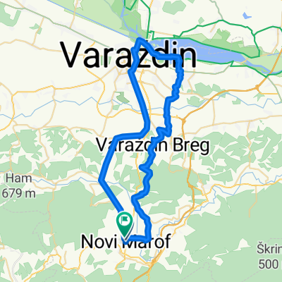
Novomarofska ruta
A cycling route starting in Remetinec, Varaždinska Županija, Croatia.
Overview
About this route
- -:--
- Duration
- 46 km
- Distance
- 426 m
- Ascent
- 425 m
- Descent
- ---
- Avg. speed
- ---
- Max. altitude
Route quality
Waytypes & surfaces along the route
Waytypes
Busy road
25.9 km
(56 %)
Road
11.4 km
(25 %)
Surfaces
Paved
21.8 km
(47 %)
Unpaved
2.9 km
(6 %)
Asphalt
21.8 km
(47 %)
Gravel
1.9 km
(4 %)
Continue with Bikemap
Use, edit, or download this cycling route
You would like to ride Novomarofska ruta or customize it for your own trip? Here is what you can do with this Bikemap route:
Free features
- Save this route as favorite or in collections
- Copy & plan your own version of this route
- Sync your route with Garmin or Wahoo
Premium features
Free trial for 3 days, or one-time payment. More about Bikemap Premium.
- Navigate this route on iOS & Android
- Export a GPX / KML file of this route
- Create your custom printout (try it for free)
- Download this route for offline navigation
Discover more Premium features.
Get Bikemap PremiumFrom our community
Other popular routes starting in Remetinec
- Šic na Bic 2016. - Bic zajaši, brega se ne plaši!
- Distance
- 43.3 km
- Ascent
- 412 m
- Descent
- 404 m
- Location
- Remetinec, Varaždinska Županija, Croatia
- Šic na Bic 2006. - Tour de Grah
- Distance
- 35.3 km
- Ascent
- 461 m
- Descent
- 461 m
- Location
- Remetinec, Varaždinska Županija, Croatia
- Šic na Bic 2010 - nije bitna ruta zajedno smo peti puta
- Distance
- 34.6 km
- Ascent
- 318 m
- Descent
- 320 m
- Location
- Remetinec, Varaždinska Županija, Croatia
- 2010 SUMMER TRIP KRK2
- Distance
- 631.7 km
- Ascent
- 2,388 m
- Descent
- 2,393 m
- Location
- Remetinec, Varaždinska Županija, Croatia
- 2009 SUMMER TRIP KRK1
- Distance
- 278.6 km
- Ascent
- 2,524 m
- Descent
- 2,204 m
- Location
- Remetinec, Varaždinska Županija, Croatia
- 2011-Mađarski gulaš - Balaton
- Distance
- 466 km
- Ascent
- 479 m
- Descent
- 483 m
- Location
- Remetinec, Varaždinska Županija, Croatia
- Šic na bic 2025. - Tour de Grah
- Distance
- 32.2 km
- Ascent
- 532 m
- Descent
- 533 m
- Location
- Remetinec, Varaždinska Županija, Croatia
- Pušta Bela (mit kurzem Fußmarsch) , Belski Dol und oberes Bednjatal
- Distance
- 26.7 km
- Ascent
- 371 m
- Descent
- 427 m
- Location
- Remetinec, Varaždinska Županija, Croatia
Open it in the app