

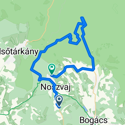
Bükk 2010.04.26. Hór-völgy
A cycling route starting in Bogács, Borsod-Abauj Zemplen county, Hungary.
Overview
About this route
- -:--
- Duration
- 49.7 km
- Distance
- 622 m
- Ascent
- 621 m
- Descent
- ---
- Avg. speed
- ---
- Max. altitude

Route highlights
Points of interest along the route

Point of interest after 1.3 km
Hór-völgy bejárata

Point of interest after 1.7 km
Suba-lyuk barlang

Point of interest after 7.3 km

Point of interest after 10.8 km
Tebe-puszta

Point of interest after 12.4 km
Üveghuta temetője

Point of interest after 13.1 km
Üveghuta
Continue with Bikemap
Use, edit, or download this cycling route
You would like to ride Bükk 2010.04.26. Hór-völgy or customize it for your own trip? Here is what you can do with this Bikemap route:
Free features
- Save this route as favorite or in collections
- Copy & plan your own version of this route
- Sync your route with Garmin or Wahoo
Premium features
Free trial for 3 days, or one-time payment. More about Bikemap Premium.
- Navigate this route on iOS & Android
- Export a GPX / KML file of this route
- Create your custom printout (try it for free)
- Download this route for offline navigation
Discover more Premium features.
Get Bikemap PremiumFrom our community
Other popular routes starting in Bogács
 Bükk 2010.04.26. Hór-völgy
- Distance
- 49.7 km
- Ascent
- 622 m
- Descent
- 621 m
- Location
- Bogács, Borsod-Abauj Zemplen county, Hungary
 CSVA - Kács - Tibolddaróc - CSVA (kis kör)
- Distance
- 25.9 km
- Ascent
- 440 m
- Descent
- 430 m
- Location
- Bogács, Borsod-Abauj Zemplen county, Hungary
 Noszvaj - Tölgyes utca
- Distance
- 33.7 km
- Ascent
- 1,164 m
- Descent
- 1,088 m
- Location
- Bogács, Borsod-Abauj Zemplen county, Hungary
 Bükkalja kör
- Distance
- 37.5 km
- Ascent
- 538 m
- Descent
- 526 m
- Location
- Bogács, Borsod-Abauj Zemplen county, Hungary
 CSVA - Noszvaj (kör)
- Distance
- 28.3 km
- Ascent
- 429 m
- Descent
- 419 m
- Location
- Bogács, Borsod-Abauj Zemplen county, Hungary
 CSVA - Noszvaj - Szomolya - Bogács - CSVA (kör)
- Distance
- 47 km
- Ascent
- 451 m
- Descent
- 463 m
- Location
- Bogács, Borsod-Abauj Zemplen county, Hungary
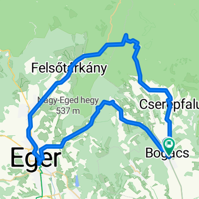 Bogács-Eger-Felsőtárkány-Bükkzsérc-Bogács
- Distance
- 52.8 km
- Ascent
- 555 m
- Descent
- 556 m
- Location
- Bogács, Borsod-Abauj Zemplen county, Hungary
 Cserépváralja Hór völgy Három-kő Bükkzsérc Cserépváralja
- Distance
- 68.1 km
- Ascent
- 917 m
- Descent
- 917 m
- Location
- Bogács, Borsod-Abauj Zemplen county, Hungary
Open it in the app