

Day 7 Lag 2
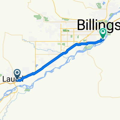
A cycling route starting in Laurel, Montana, United States.
Overview
About this route
soert trip found a house WS might be the last hous for awile Trump in town
- -:--
- Duration
- 29 km
- Distance
- 34 m
- Ascent
- 58 m
- Descent
- ---
- Avg. speed
- ---
- Max. altitude

Route quality
Waytypes & surfaces along the route
Waytypes
Quiet road
9 km
(31 %)
Road
8.4 km
(29 %)
Surfaces
Paved
2.3 km
(8 %)
Asphalt
2.3 km
(8 %)
Undefined
26.7 km
(92 %)
Continue with Bikemap
Use, edit, or download this cycling route
You would like to ride Day 7 Lag 2 or customize it for your own trip? Here is what you can do with this Bikemap route:
Free features
- Save this route as favorite or in collections
- Copy & plan your own version of this route
- Sync your route with Garmin or Wahoo
Premium features
Free trial for 3 days, or one-time payment. More about Bikemap Premium.
- Navigate this route on iOS & Android
- Export a GPX / KML file of this route
- Create your custom printout (try it for free)
- Download this route for offline navigation
Discover more Premium features.
Get Bikemap PremiumFrom our community
Other popular routes starting in Laurel
 Day 7 Lag 2
- Distance
- 29 km
- Ascent
- 34 m
- Descent
- 58 m
- Location
- Laurel, Montana, United States
 64–92 River Rd, Joliet to 52–98 11th St E, Red Lodge
- Distance
- 81.9 km
- Ascent
- 996 m
- Descent
- 335 m
- Location
- Laurel, Montana, United States
 Bernhardt Road to KOA Billings RV
- Distance
- 25.6 km
- Ascent
- 17 m
- Descent
- 54 m
- Location
- Laurel, Montana, United States
 Laurel to Montagua Montana
- Distance
- 64.5 km
- Ascent
- 572 m
- Descent
- 314 m
- Location
- Laurel, Montana, United States
 River Loop
- Distance
- 33.2 km
- Ascent
- 95 m
- Descent
- 97 m
- Location
- Laurel, Montana, United States
 Work Route
- Distance
- 19.4 km
- Ascent
- 37 m
- Descent
- 74 m
- Location
- Laurel, Montana, United States
 64–92 River Rd, Joliet to 52–98 11th St E, Red Lodge
- Distance
- 70.3 km
- Ascent
- 1,083 m
- Descent
- 421 m
- Location
- Laurel, Montana, United States
 Red Lodge
- Distance
- 75.4 km
- Ascent
- 761 m
- Descent
- 119 m
- Location
- Laurel, Montana, United States
Open it in the app