

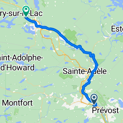
Shawbridge - Route 370 (Ch. Pierre-Péladeau)
A cycling route starting in Prévost, Quebec, Canada.
Overview
About this route
Piste cyclable le P'tit train du nord.
En montée presque continue mais graduelle de Shawbridge à la route 370.
Surface en concassé Merveilleux pour un Vélo tout-terrain, mais accessible au vélo de route.
P'tit train du nord bike trail
From Shawbridge to Hwy 370 it is a near continuous yet gradual climb.
Hard packed surface, ideal for all-terrain bike, but accessible to road bike.
- -:--
- Duration
- 18.7 km
- Distance
- 194 m
- Ascent
- 95 m
- Descent
- ---
- Avg. speed
- ---
- Max. altitude

Route quality
Waytypes & surfaces along the route
Waytypes
Cycleway
18.7 km
(100 %)
Surfaces
Paved
0.2 km
(1 %)
Unpaved
18.5 km
(99 %)
Gravel
18.5 km
(99 %)
Asphalt
0.2 km
(1 %)
Continue with Bikemap
Use, edit, or download this cycling route
You would like to ride Shawbridge - Route 370 (Ch. Pierre-Péladeau) or customize it for your own trip? Here is what you can do with this Bikemap route:
Free features
- Save this route as favorite or in collections
- Copy & plan your own version of this route
- Sync your route with Garmin or Wahoo
Premium features
Free trial for 3 days, or one-time payment. More about Bikemap Premium.
- Navigate this route on iOS & Android
- Export a GPX / KML file of this route
- Create your custom printout (try it for free)
- Download this route for offline navigation
Discover more Premium features.
Get Bikemap PremiumFrom our community
Other popular routes starting in Prévost
 Ch de Vimy, Piedmont à Ch de Vimy, Piedmont
- Distance
- 36.7 km
- Ascent
- 802 m
- Descent
- 810 m
- Location
- Prévost, Quebec, Canada
 Route to Kingston
- Distance
- 401.6 km
- Ascent
- 1,098 m
- Descent
- 1,190 m
- Location
- Prévost, Quebec, Canada
 Maison St hypo Ste-Adèle Prévost
- Distance
- 30 km
- Ascent
- 375 m
- Descent
- 377 m
- Location
- Prévost, Quebec, Canada
 Prévost_Côte du Lac-de-l'Achigan_Ste-Anne-des-Lacs CLONED FROM ROUTE 1293980
- Distance
- 87.9 km
- Ascent
- 827 m
- Descent
- 698 m
- Location
- Prévost, Quebec, Canada
 ste anne des lacs, ste adèle, prévost
- Distance
- 50.2 km
- Ascent
- 707 m
- Descent
- 794 m
- Location
- Prévost, Quebec, Canada
 Petit train du nord
- Distance
- 36.5 km
- Ascent
- 314 m
- Descent
- 169 m
- Location
- Prévost, Quebec, Canada
 Saint-Hiippolyte loop
- Distance
- 51.8 km
- Ascent
- 591 m
- Descent
- 593 m
- Location
- Prévost, Quebec, Canada
 st-anne des lacs- pays den haut---710m CLONED FROM ROUTE 1523727
- Distance
- 63 km
- Ascent
- 599 m
- Descent
- 601 m
- Location
- Prévost, Quebec, Canada
Open it in the app