

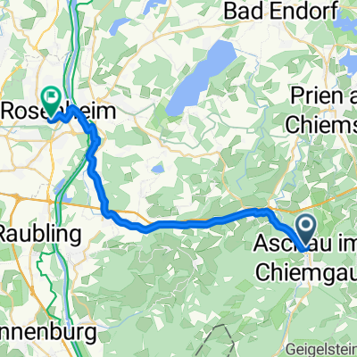
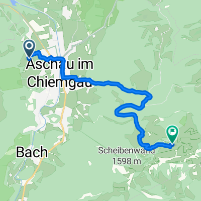
Aschau-Samerberg-Aschau
A cycling route starting in Aschau im Chiemgau, Bavaria, Germany.
Overview
About this route
- -:--
- Duration
- 76.3 km
- Distance
- 882 m
- Ascent
- 491 m
- Descent
- ---
- Avg. speed
- ---
- Max. altitude
Continue with Bikemap
Use, edit, or download this cycling route
You would like to ride Aschau-Samerberg-Aschau or customize it for your own trip? Here is what you can do with this Bikemap route:
Free features
- Save this route as favorite or in collections
- Copy & plan your own version of this route
- Sync your route with Garmin or Wahoo
Premium features
Free trial for 3 days, or one-time payment. More about Bikemap Premium.
- Navigate this route on iOS & Android
- Export a GPX / KML file of this route
- Create your custom printout (try it for free)
- Download this route for offline navigation
Discover more Premium features.
Get Bikemap PremiumFrom our community
Other popular routes starting in Aschau im Chiemgau
 über den Reitweg zur Gorealm
- Distance
- 14 km
- Ascent
- 722 m
- Descent
- 719 m
- Location
- Aschau im Chiemgau, Bavaria, Germany
 Aschau Rosenheim
- Distance
- 24.1 km
- Ascent
- 83 m
- Descent
- 236 m
- Location
- Aschau im Chiemgau, Bavaria, Germany
 GPX Download: Kampenwand-Umrundung (MTB-Tour: 3) – Chiemgauer Alpen
- Distance
- 84.5 km
- Ascent
- 4,639 m
- Descent
- 4,250 m
- Location
- Aschau im Chiemgau, Bavaria, Germany
 Aschau-Kampenwand
- Distance
- 8.4 km
- Ascent
- 856 m
- Descent
- 34 m
- Location
- Aschau im Chiemgau, Bavaria, Germany
 Lautern nach Bad Feilnbach
- Distance
- 34 km
- Ascent
- 159 m
- Descent
- 285 m
- Location
- Aschau im Chiemgau, Bavaria, Germany
 Rund um den Geigelstein
- Distance
- 41.4 km
- Ascent
- 838 m
- Descent
- 838 m
- Location
- Aschau im Chiemgau, Bavaria, Germany
 Schachenberg
- Distance
- 4.4 km
- Ascent
- 379 m
- Descent
- 376 m
- Location
- Aschau im Chiemgau, Bavaria, Germany
 Chiemseerunde
- Distance
- 107.1 km
- Ascent
- 417 m
- Descent
- 417 m
- Location
- Aschau im Chiemgau, Bavaria, Germany
Open it in the app