

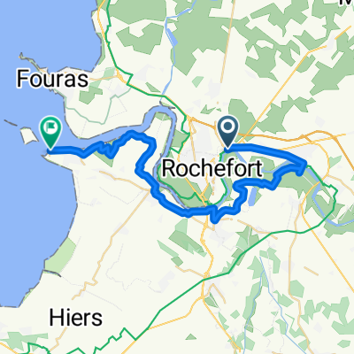
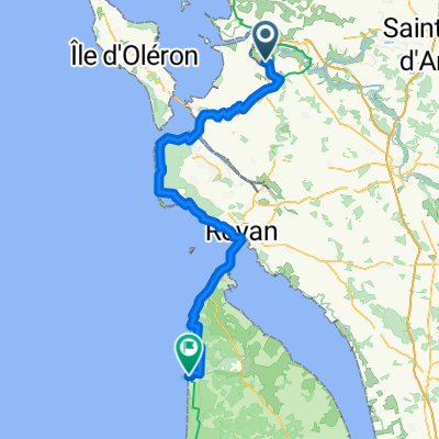
Etapa 015C (Rochefort - Le Rocher)
A cycling route starting in Rochefort, Nouvelle-Aquitaine, France.
Overview
About this route
Vuelta a Europa occidental. Etapa 15
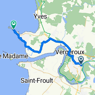
Rochefort - Châtelaillon Plage - Angoulins - La Rochelle - Dompierre sur Mer - Marans - Saint Michel en l'Herm - L'Aiguillon sur Mer - La Tranche sur Mer - La Terrière - Le Rocher
134.8 km
160 m desnivel acumulado positivo
- -:--
- Duration
- 134.8 km
- Distance
- 162 m
- Ascent
- 154 m
- Descent
- ---
- Avg. speed
- 33 m
- Max. altitude

Route quality
Waytypes & surfaces along the route
Waytypes
Quiet road
41.8 km
(31 %)
Cycleway
36.4 km
(27 %)
Surfaces
Paved
66.1 km
(49 %)
Unpaved
32.4 km
(24 %)
Asphalt
64.7 km
(48 %)
Gravel
27 km
(20 %)
Route highlights
Points of interest along the route
Point of interest after 46.4 km
Torre de San Nicolás
Point of interest after 47.2 km
Torre de la Cadena
Point of interest after 47.5 km
Torre de la Linterna
Point of interest after 48 km
Grosse Horloge
Point of interest after 48.4 km
Ayuntamiento
Point of interest after 48.6 km
Mercado
Point of interest after 98.1 km
Abadía Real
Accommodation after 134.8 km
Camping Le Petit Rocher
Continue with Bikemap
Use, edit, or download this cycling route
You would like to ride Etapa 015C (Rochefort - Le Rocher) or customize it for your own trip? Here is what you can do with this Bikemap route:
Free features
- Save this route as favorite or in collections
- Copy & plan your own version of this route
- Split it into stages to create a multi-day tour
- Sync your route with Garmin or Wahoo
Premium features
Free trial for 3 days, or one-time payment. More about Bikemap Premium.
- Navigate this route on iOS & Android
- Export a GPX / KML file of this route
- Create your custom printout (try it for free)
- Download this route for offline navigation
Discover more Premium features.
Get Bikemap PremiumFrom our community
Other popular routes starting in Rochefort
 Rochefort - Port des Barques
- Distance
- 33.5 km
- Ascent
- 56 m
- Descent
- 55 m
- Location
- Rochefort, Nouvelle-Aquitaine, France
 Tout droit à l'intérieur Rochefort
- Distance
- 21.7 km
- Ascent
- 80 m
- Descent
- 80 m
- Location
- Rochefort, Nouvelle-Aquitaine, France
 Rochefort quai aux vivres Fouras
- Distance
- 19.9 km
- Ascent
- 48 m
- Descent
- 56 m
- Location
- Rochefort, Nouvelle-Aquitaine, France
 De Rue Chanzy à Boulevard de la Fumée
- Distance
- 21.8 km
- Ascent
- 181 m
- Descent
- 244 m
- Location
- Rochefort, Nouvelle-Aquitaine, France
 De Quai aux Vivres à Place de l'Abbaye
- Distance
- 52.6 km
- Ascent
- 270 m
- Descent
- 314 m
- Location
- Rochefort, Nouvelle-Aquitaine, France
 circuit #6 ride découverte Charente-Maritime
- Distance
- 139.6 km
- Ascent
- 446 m
- Descent
- 411 m
- Location
- Rochefort, Nouvelle-Aquitaine, France
 06 Rochefort to Chenac-Saint-Montalivet les Bains 110
- Distance
- 108.6 km
- Ascent
- 237 m
- Descent
- 230 m
- Location
- Rochefort, Nouvelle-Aquitaine, France
 1992 - Atlantik - Mosel - 2. Tag - Rochefort - Parthenay
- Distance
- 107.7 km
- Ascent
- 458 m
- Descent
- 301 m
- Location
- Rochefort, Nouvelle-Aquitaine, France
Open it in the app