- 51.6 km
- 20 m
- 16 m
- Les Moutiers-en-Retz, Pays de la Loire Region, France
Etapa 017C (Les Moutiers en Retz - Nantes)
A cycling route starting in Les Moutiers-en-Retz, Pays de la Loire Region, France.
Overview
About this route
Western Europe Tour. Stage 17
Les Moutiers en Retz - La Bernerie en Retz - Pornic - Préfailles - Saint Michel Chef Chef - L'Hermitage - Les Rochelets - Saint Brevin les Pins - Mindin - Paimboeuf - Le Pellerin - Saint Jean de Boiseau - La Montagne - Bouguenais - Nantes
129.6 km
540 m total positive elevation gain
- -:--
- Duration
- 129.6 km
- Distance
- 537 m
- Ascent
- 537 m
- Descent
- ---
- Avg. speed
- 40 m
- Max. altitude
created this 7 years ago
Route quality
Waytypes & surfaces along the route
Waytypes
Quiet road
62.2 km
(48 %)
Road
16.8 km
(13 %)
Surfaces
Paved
92 km
(71 %)
Unpaved
20.7 km
(16 %)
Asphalt
88.1 km
(68 %)
Gravel
18.1 km
(14 %)
Route highlights
Points of interest along the route
Point of interest after 12.9 km
Castillo
Point of interest after 13.3 km
Iglesia
Point of interest after 13.5 km
Mercado
Point of interest after 51.5 km
Serpent de l'Ocean
Point of interest after 66.1 km
Le Jardin Étoilé
Point of interest after 115 km
Machines de l'Ile
Point of interest after 116.1 km
Passage Pommeraye
Point of interest after 116.2 km
Place du Commerce
Point of interest after 116.7 km
Place de Bouffay
Point of interest after 117.2 km
Place Royale
Point of interest after 117.7 km
Place de Bretagne
Point of interest after 118.2 km
Mercado Talensac
Point of interest after 118.9 km
Catedral de San Pedro y San Pablo
Point of interest after 119.3 km
Château des Ducs de Bretagne
Point of interest after 120.1 km
Le Lieu Unique
Accommodation after 129.6 km
Camping Belle Rivière
Continue with Bikemap
Use, edit, or download this cycling route
You would like to ride Etapa 017C (Les Moutiers en Retz - Nantes) or customize it for your own trip? Here is what you can do with this Bikemap route:
Free features
- Save this route as favorite or in collections
- Copy & plan your own version of this route
- Split it into stages to create a multi-day tour
- Sync your route with Garmin or Wahoo
Premium features
Free trial for 3 days, or one-time payment. More about Bikemap Premium.
- Navigate this route on iOS & Android
- Export a GPX / KML file of this route
- Create your custom printout (try it for free)
- Download this route for offline navigation
Discover more Premium features.
Get Bikemap PremiumFrom our community
Other popular routes starting in Les Moutiers-en-Retz
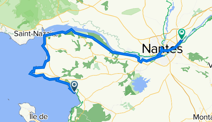
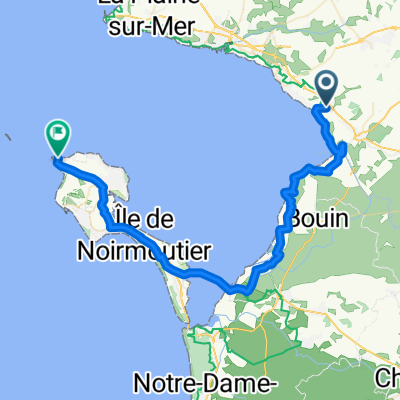
- 03_Les-Moutiers-en-Retz_Noirmoutier-La Marine
- Bretagne Pornic
- 31.9 km
- 72 m
- 75 m
- Les Moutiers-en-Retz, Pays de la Loire Region, France
- Itinéraire vers 2 Place de la Victoire, Saint-Brevin-les-Pins
- 36.3 km
- 187 m
- 181 m
- Les Moutiers-en-Retz, Pays de la Loire Region, France
- De Route de Moraudeau 4, Les Moutiers-en-Retz à Le Port du Bec, Bouin
- 20.4 km
- 27 m
- 36 m
- Les Moutiers-en-Retz, Pays de la Loire Region, France
- training
- 31.9 km
- 82 m
- 84 m
- Les Moutiers-en-Retz, Pays de la Loire Region, France
- De Route de Moraudeau 4, Les Moutiers-en-Retz à La Noue Mossart 500, Saint-Gervais
- 25.6 km
- 36 m
- 23 m
- Les Moutiers-en-Retz, Pays de la Loire Region, France
- Itinéraire à partir de Le Parubo, Pornic
- 13.8 km
- 0 m
- 18 m
- Les Moutiers-en-Retz, Pays de la Loire Region, France
- roller moutiers
- 18.9 km
- 156 m
- 160 m
- Les Moutiers-en-Retz, Pays de la Loire Region, France
Open it in the app


