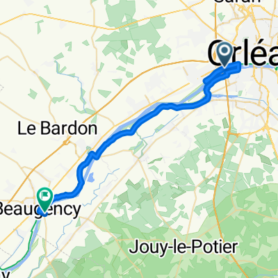
Etapa 021C (Orléans - Montargis)
- 154 km
- 593 m
- 588 m
- Saint-Pryvé-Saint-Mesmin, Centre-Val de Loire, France
A cycling route starting in Saint-Pryvé-Saint-Mesmin, Centre-Val de Loire, France.
Overview
Vuelta a Europa occidental. Etapa 21
Orléans - Jargeau - Châteauneuf sur Loire - Saint-Benoît sur Loire - Saint Père sur Loire - Sully sur Loire - Lion en Sullias - Saint Florent - Saint Gondon - Gien - Saint Martin sur Ocre - Saint-Brisson sur Loire - Briare - Ouzouer sur Trézée - Rogny les Sept Écluses - Châtillon Coligny - Montbouy - Montargis
154.0 km
590 m desnivel positivo acumulado.
created this 7 years ago
Route quality
Quiet road
61.6 km
(40 %)
Cycleway
58.5 km
(38 %)
Paved
110.9 km
(72 %)
Unpaved
10.8 km
(7 %)
Asphalt
104.7 km
(68 %)
Gravel
7.7 km
(5 %)
Route highlights
Maison de Jeanne d'Arc
Place du Martroi
Hotel Groslot
Catedral de la Santa Cruz
Eglise Saint-Etienne
Château de Sully-sur-Loire
Vieux Pont de Gien
Église Saint-Étienne de Briare
Les 7 ecluses
Camping de la Forêt
Continue with Bikemap
You would like to ride Etapa 021C (Orléans - Montargis) or customize it for your own trip? Here is what you can do with this Bikemap route:
Free trial for 3 days, or one-time payment. More about Bikemap Premium.
Discover more Premium features.
Get Bikemap PremiumFrom our community
Open it in the app