

Prádena
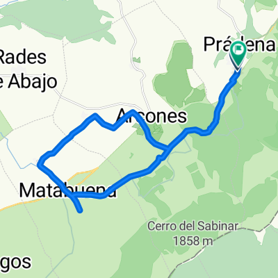
De Prádena al campo de golf de Matabuena
A cycling route starting in Prádena, Castille and León, Spain.
Overview
About this route
- -:--
- Duration
- 20.5 km
- Distance
- 121 m
- Ascent
- 125 m
- Descent
- ---
- Avg. speed
- ---
- Max. altitude

Part of
Prádena
8 stages
Route quality
Waytypes & surfaces along the route
Waytypes
Quiet road
8.6 km
(42 %)
Track
5.3 km
(26 %)
Surfaces
Paved
1.6 km
(8 %)
Unpaved
7.6 km
(37 %)
Gravel
4.9 km
(24 %)
Unpaved (undefined)
1.6 km
(8 %)
Route highlights
Points of interest along the route
Point of interest after 8.5 km
Campo de Golf de Matabuena
Continue with Bikemap
Use, edit, or download this cycling route
You would like to ride De Prádena al campo de golf de Matabuena or customize it for your own trip? Here is what you can do with this Bikemap route:
Free features
- Save this route as favorite or in collections
- Copy & plan your own version of this route
- Sync your route with Garmin or Wahoo
Premium features
Free trial for 3 days, or one-time payment. More about Bikemap Premium.
- Navigate this route on iOS & Android
- Export a GPX / KML file of this route
- Create your custom printout (try it for free)
- Download this route for offline navigation
Discover more Premium features.
Get Bikemap PremiumFrom our community
Other popular routes starting in Prádena
 De Prádena al campo de golf de Matabuena
- Distance
- 20.5 km
- Ascent
- 121 m
- Descent
- 125 m
- Location
- Prádena, Castille and León, Spain
 De Prádena a Sanchopedro, Orejanilla, Las Rades de Pedraza, Huerta, Arcones y Prádena
- Distance
- 28.2 km
- Ascent
- 290 m
- Descent
- 289 m
- Location
- Prádena, Castille and León, Spain
 número uno
- Distance
- 31 km
- Ascent
- 515 m
- Descent
- 508 m
- Location
- Prádena, Castille and León, Spain
 De Prádena al puerto de La Acebeda y vuelta por el puerto de Arcones
- Distance
- 24.7 km
- Ascent
- 693 m
- Descent
- 699 m
- Location
- Prádena, Castille and León, Spain
 p´radena de segobia-pedraza-castrosernas
- Distance
- 66.7 km
- Ascent
- 611 m
- Descent
- 613 m
- Location
- Prádena, Castille and León, Spain
 Prádena-Bola del Mundo
- Distance
- 148.2 km
- Ascent
- 3,322 m
- Descent
- 2,185 m
- Location
- Prádena, Castille and León, Spain
 Subida al Hito de Colgadizos desde Prádena
- Distance
- 12 km
- Ascent
- 716 m
- Descent
- 16 m
- Location
- Prádena, Castille and León, Spain
 De Prádena a Navafría por la Cañada Real y vuelta
- Distance
- 38.9 km
- Ascent
- 396 m
- Descent
- 397 m
- Location
- Prádena, Castille and León, Spain
Open it in the app