

2020 Ruta Nº 65
A cycling route starting in Valladolid, Castille and León, Spain.
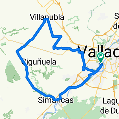
Overview
About this route
Ronda -Ctra.Segovia - Rotonda Otero -Tudela -La parrilla -Montemayor -Viloria del Henar -San Miguel del Arroyo -Megeces -Portillo -La Pedraja -(rotonda el Otero)-La Corala- Valladolid.
1ª Cuesta La Parrilla Pendiente media 5,2% Distancia 3 Km.
2ª La Garganta - VteSur Pendiente media 5,3% - Distancia 2,2 Km.
- -:--
- Duration
- 99.9 km
- Distance
- 443 m
- Ascent
- 447 m
- Descent
- ---
- Avg. speed
- ---
- Max. altitude

Route quality
Waytypes & surfaces along the route
Waytypes
Road
63.9 km
(64 %)
Quiet road
12 km
(12 %)
Surfaces
Paved
70.9 km
(71 %)
Unpaved
5 km
(5 %)
Asphalt
70.9 km
(71 %)
Gravel
4 km
(4 %)
Route highlights
Points of interest along the route
Point of interest after 27.8 km
Cuesta La Parrilla Pendiente media 5,2% Distancia 3 Km.
Point of interest after 68.3 km
La Garganta - VteSur Pendiente media 5,3% - Distancia 2,2 Km.
Continue with Bikemap
Use, edit, or download this cycling route
You would like to ride 2020 Ruta Nº 65 or customize it for your own trip? Here is what you can do with this Bikemap route:
Free features
- Save this route as favorite or in collections
- Copy & plan your own version of this route
- Split it into stages to create a multi-day tour
- Sync your route with Garmin or Wahoo
Premium features
Free trial for 3 days, or one-time payment. More about Bikemap Premium.
- Navigate this route on iOS & Android
- Export a GPX / KML file of this route
- Create your custom printout (try it for free)
- Download this route for offline navigation
Discover more Premium features.
Get Bikemap PremiumFrom our community
Other popular routes starting in Valladolid
 2021 - Ruta nº 51
- Distance
- 84.5 km
- Ascent
- 390 m
- Descent
- 384 m
- Location
- Valladolid, Castille and León, Spain
 Ciguñuela
- Distance
- 16.3 km
- Ascent
- 200 m
- Descent
- 103 m
- Location
- Valladolid, Castille and León, Spain
 Zaratán - Villanubla - Simancas
- Distance
- 44.5 km
- Ascent
- 254 m
- Descent
- 255 m
- Location
- Valladolid, Castille and León, Spain
 Orilla Rio
- Distance
- 40.3 km
- Ascent
- 115 m
- Descent
- 115 m
- Location
- Valladolid, Castille and León, Spain
 2022 - Ruta nº 062
- Distance
- 118.5 km
- Ascent
- 683 m
- Descent
- 686 m
- Location
- Valladolid, Castille and León, Spain
 Ruta: 20-Mayo-2018 - (PM - Amistad)
- Distance
- 92.8 km
- Ascent
- 435 m
- Descent
- 431 m
- Location
- Valladolid, Castille and León, Spain
 2022 - Ruta nº 059
- Distance
- 130.1 km
- Ascent
- 733 m
- Descent
- 733 m
- Location
- Valladolid, Castille and León, Spain
 2022 - Ruta nº 063
- Distance
- 100.1 km
- Ascent
- 201 m
- Descent
- 199 m
- Location
- Valladolid, Castille and León, Spain
Open it in the app