

2020 Ruta Nº 67
A cycling route starting in Valladolid, Castille and León, Spain.
Overview
About this route
Pte Mayor -Fuensaldaña - Mucientes -Villalba de los Alcores -Valdenebro -Medina De Rioseco -Castromonte -Torrelobaton -Wamba -Valladolid.
1º Subida: Trastada Pendiente media 4,50% Longitud: 1,3 Km.
2º Subida: Montes Torozos Pendiente media 4.20% Distancia 3,2 km
3ª Subida: El Espolón Pendiente media 3.00% Distancia 2.1 Km
4ª Subida: Carra Pendiente media 5,90% Distancia 1,1 Km.
- -:--
- Duration
- 103.1 km
- Distance
- 421 m
- Ascent
- 423 m
- Descent
- ---
- Avg. speed
- ---
- Max. altitude

Route quality
Waytypes & surfaces along the route
Waytypes
Road
38.2 km
(37 %)
Track
9.3 km
(9 %)
Surfaces
Paved
86.6 km
(84 %)
Unpaved
3.1 km
(3 %)
Asphalt
85.6 km
(83 %)
Paved (undefined)
1 km
(1 %)
Route highlights
Points of interest along the route
Point of interest after 8.9 km
1º Subida: Trastada Pendiente media 4,50% Longitud: 1,3 Km.
Point of interest after 14.5 km
2º Subida: Montes Torozos Pendiente media 4.20% Distancia 3,2 km
Point of interest after 52.4 km
3ª Subida: El Espolón Pendiente media 3.00% Distancia 2.1 Km
Point of interest after 82.9 km
4ª Subida: Carra Pendiente media 5,90% Distancia 1,1 Km.
Continue with Bikemap
Use, edit, or download this cycling route
You would like to ride 2020 Ruta Nº 67 or customize it for your own trip? Here is what you can do with this Bikemap route:
Free features
- Save this route as favorite or in collections
- Copy & plan your own version of this route
- Split it into stages to create a multi-day tour
- Sync your route with Garmin or Wahoo
Premium features
Free trial for 3 days, or one-time payment. More about Bikemap Premium.
- Navigate this route on iOS & Android
- Export a GPX / KML file of this route
- Create your custom printout (try it for free)
- Download this route for offline navigation
Discover more Premium features.
Get Bikemap PremiumFrom our community
Other popular routes starting in Valladolid
 Ruta: 20-Mayo-2018 - (PM - Amistad)
- Distance
- 92.8 km
- Ascent
- 435 m
- Descent
- 431 m
- Location
- Valladolid, Castille and León, Spain
 2022 - Ruta nº 073
- Distance
- 98.2 km
- Ascent
- 439 m
- Descent
- 442 m
- Location
- Valladolid, Castille and León, Spain
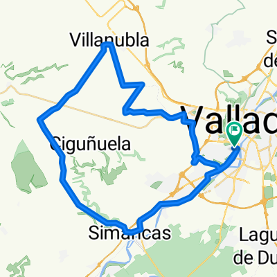 Zaratán - Villanubla - Simancas
- Distance
- 44.5 km
- Ascent
- 254 m
- Descent
- 255 m
- Location
- Valladolid, Castille and León, Spain
 Ciguñuela
- Distance
- 16.3 km
- Ascent
- 200 m
- Descent
- 103 m
- Location
- Valladolid, Castille and León, Spain
 Circuito: VAREVITUCI
- Distance
- 37.6 km
- Ascent
- 303 m
- Descent
- 303 m
- Location
- Valladolid, Castille and León, Spain
 2022 - Ruta nº 059
- Distance
- 130.1 km
- Ascent
- 733 m
- Descent
- 733 m
- Location
- Valladolid, Castille and León, Spain
 Orilla Rio
- Distance
- 40.3 km
- Ascent
- 115 m
- Descent
- 115 m
- Location
- Valladolid, Castille and León, Spain
 vueltecilla mtb
- Distance
- 21.9 km
- Ascent
- 168 m
- Descent
- 159 m
- Location
- Valladolid, Castille and León, Spain
Open it in the app