SF TdA HC 106 km
- 105.5 km
- 1,244 m
- 1,244 m
- Weilheim an der Teck, Baden-Wurttemberg, Germany
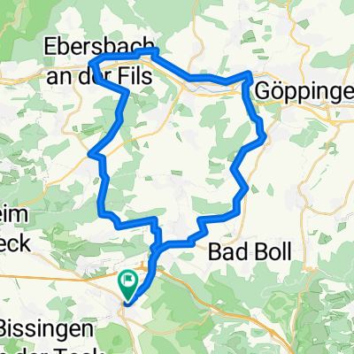
A cycling route starting in Weilheim an der Teck, Baden-Wurttemberg, Germany.
Overview
Difficult tour: 37.2 km, approx. 703 m elevation gain(Weilheim - Bissingen - Sattelbogen - Bahnhöfle - Reußenstein - Weilheim Ski Hut - Deutsches Haus - Forest Station - Entenmann Garden Center - return)
From Weilheim, take the bike path to Bissingen. From here, go via the sheep pen to the drinking water reservoir at Sattelbogen. Then turn left steeply uphill, passing Engelhof and follow the path to the hiking parking lot "Bahnhöfle". (Signage: Randeck, Bahnhöfle, Gutenberger Caves via Torfgrube). Here turn left towards Reußenstein. Pass the Reußensteiner farm and follow the path along the pasture. Cross the Neidlinger Steige at the horse paddock and follow the path parallel to the Albtrauf edge.
At a fork in the path, turn sharp left and follow the gravel road, partially parallel to the high-voltage line, to Bosslerhaus. Here follow the field path downhill, later asphalt, to the main road. Turn left onto the connecting road Gruibingen-Weilheim, pass the inn "Zum deutschen Haus" (alternative: follow the road downhill briefly, then turn left and return to Weilheim via Häringen and Egenfirst) and then turn right and follow the path back to Weilheim. At the path junction above Weilheim, follow the path downhill to the right (alternative: detour to the Entenmann Garden Center) to the entrance of Weilheim. Pass through the town via Weilerweg, Brunnenstraße, Lindachbrücke, Bissinger Straße back to the starting point.
created this 15 years ago
Route quality
Track
29 km
(78 %)
Quiet road
5.2 km
(14 %)
Paved
14.1 km
(38 %)
Unpaved
21.2 km
(57 %)
Gravel
14.1 km
(38 %)
Asphalt
10.4 km
(28 %)
Continue with Bikemap
You would like to ride Mountainbike Tour Schwer or customize it for your own trip? Here is what you can do with this Bikemap route:
Free trial for 3 days, or one-time payment. More about Bikemap Premium.
Discover more Premium features.
Get Bikemap PremiumFrom our community
Open it in the app