

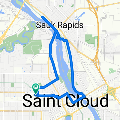
Day 22 Lag 2
A cycling route starting in Saint Cloud, Minnesota, United States.
Overview
About this route
On to Minneapolis alot of nice bike paths Luce line trail, MRT and the Medicine Lake, staying with fireds till Saturday went to Park Tavern and sightseeing three pictures are from Tettegoucho State Park area starting Lag 3 9/30
- -:--
- Duration
- 123.7 km
- Distance
- 115 m
- Ascent
- 164 m
- Descent
- ---
- Avg. speed
- ---
- Max. altitude

Route photos


Route quality
Waytypes & surfaces along the route
Waytypes
Quiet road
22.3 km
(18 %)
Cycleway
18.6 km
(15 %)
Surfaces
Paved
87.9 km
(71 %)
Asphalt
68.1 km
(55 %)
Paved (undefined)
18.6 km
(15 %)
Continue with Bikemap
Use, edit, or download this cycling route
You would like to ride Day 22 Lag 2 or customize it for your own trip? Here is what you can do with this Bikemap route:
Free features
- Save this route as favorite or in collections
- Copy & plan your own version of this route
- Split it into stages to create a multi-day tour
- Sync your route with Garmin or Wahoo
Premium features
Free trial for 3 days, or one-time payment. More about Bikemap Premium.
- Navigate this route on iOS & Android
- Export a GPX / KML file of this route
- Create your custom printout (try it for free)
- Download this route for offline navigation
Discover more Premium features.
Get Bikemap PremiumFrom our community
Other popular routes starting in Saint Cloud
 Riverside
- Distance
- 81.2 km
- Ascent
- 171 m
- Descent
- 174 m
- Location
- Saint Cloud, Minnesota, United States
 6th Avenue North 1406, St. Cloud to 6th Avenue North 1109, St. Cloud
- Distance
- 10 km
- Ascent
- 75 m
- Descent
- 79 m
- Location
- Saint Cloud, Minnesota, United States
 Day 22 Lag 2
- Distance
- 123.7 km
- Ascent
- 115 m
- Descent
- 164 m
- Location
- Saint Cloud, Minnesota, United States
 2006 Veterans Dr, Saint Cloud to 1900 Veterans Dr, Saint Cloud
- Distance
- 18.3 km
- Ascent
- 79 m
- Descent
- 79 m
- Location
- Saint Cloud, Minnesota, United States
 1900 Veterans Dr, Saint Cloud to 1900 Veterans Dr, Saint Cloud
- Distance
- 12 km
- Ascent
- 61 m
- Descent
- 58 m
- Location
- Saint Cloud, Minnesota, United States
 round river 2 with lora
- Distance
- 7.8 km
- Ascent
- 57 m
- Descent
- 56 m
- Location
- Saint Cloud, Minnesota, United States
 Beaver Island 3KM
- Distance
- 3 km
- Ascent
- 17 m
- Descent
- 17 m
- Location
- Saint Cloud, Minnesota, United States
 Riverside
- Distance
- 8.4 km
- Ascent
- 31 m
- Descent
- 33 m
- Location
- Saint Cloud, Minnesota, United States
Open it in the app