

Gantrisch Bike-Panoramaweg
A cycling route starting in Blumenstein, Canton of Bern, Switzerland.
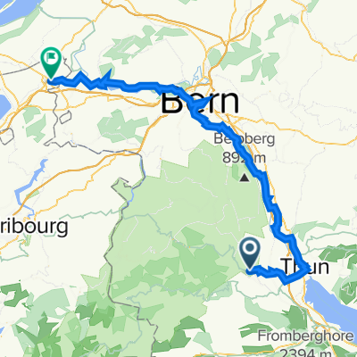
Overview
About this route
The «Gantrisch Bike-Panoramaweg» is considered a beginners tour in the Gantrisch Biking portfolio and allows plenty of time to enjoy the beautiful scenery.
- -:--
- Duration
- 15.6 km
- Distance
- 317 m
- Ascent
- 317 m
- Descent
- ---
- Avg. speed
- ---
- Max. altitude
Route quality
Waytypes & surfaces along the route
Waytypes
Quiet road
6.3 km
(40 %)
Track
5.1 km
(32 %)
Surfaces
Paved
4 km
(26 %)
Unpaved
9.6 km
(61 %)
Unpaved (undefined)
6.1 km
(39 %)
Asphalt
4 km
(26 %)
Continue with Bikemap
Use, edit, or download this cycling route
You would like to ride Gantrisch Bike-Panoramaweg or customize it for your own trip? Here is what you can do with this Bikemap route:
Free features
- Save this route as favorite or in collections
- Copy & plan your own version of this route
- Sync your route with Garmin or Wahoo
Premium features
Free trial for 3 days, or one-time payment. More about Bikemap Premium.
- Navigate this route on iOS & Android
- Export a GPX / KML file of this route
- Create your custom printout (try it for free)
- Download this route for offline navigation
Discover more Premium features.
Get Bikemap PremiumFrom our community
Other popular routes starting in Blumenstein
 Forst-Längenbühl - Hippel Kerzers
- Distance
- 67.2 km
- Ascent
- 540 m
- Descent
- 744 m
- Location
- Blumenstein, Canton of Bern, Switzerland
 Gatrisch
- Distance
- 56.3 km
- Ascent
- 1,283 m
- Descent
- 1,261 m
- Location
- Blumenstein, Canton of Bern, Switzerland
 G-P-C Teil 4
- Distance
- 38.1 km
- Ascent
- 199 m
- Descent
- 1,250 m
- Location
- Blumenstein, Canton of Bern, Switzerland
 Gurnigel Abstieg nach Zentrum
- Distance
- 34.4 km
- Ascent
- 330 m
- Descent
- 1,099 m
- Location
- Blumenstein, Canton of Bern, Switzerland
 Blumenstein - Gantrisch - retour
- Distance
- 11.9 km
- Ascent
- 1,031 m
- Descent
- 81 m
- Location
- Blumenstein, Canton of Bern, Switzerland
 Blumenstein Gurnigel Leiterenp. Stockh. Erlenb. Blumenstein
- Distance
- 56.1 km
- Ascent
- 1,749 m
- Descent
- 1,749 m
- Location
- Blumenstein, Canton of Bern, Switzerland
 Staffelalp
- Distance
- 56.4 km
- Ascent
- 1,250 m
- Descent
- 1,218 m
- Location
- Blumenstein, Canton of Bern, Switzerland
 lzg bis ottenleue
- Distance
- 49.6 km
- Ascent
- 1,147 m
- Descent
- 1,953 m
- Location
- Blumenstein, Canton of Bern, Switzerland
Open it in the app