
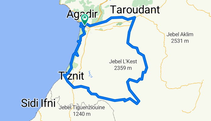
AntiAtlas Velo tour
A cycling route starting in Inezgane, Région de Souss-Massa-Drâa, Morocco.
Overview
About this route
- -:--
- Duration
- 521.6 km
- Distance
- 2,889 m
- Ascent
- 2,889 m
- Descent
- ---
- Avg. speed
- ---
- Max. altitude

Route quality
Waytypes & surfaces along the route
Waytypes
Road
203.4 km
(39 %)
Quiet road
88.7 km
(17 %)
Surfaces
Paved
339 km
(65 %)
Unpaved
57.4 km
(11 %)
Asphalt
339 km
(65 %)
Unpaved (undefined)
20.9 km
(4 %)
Continue with Bikemap
Use, edit, or download this cycling route
You would like to ride AntiAtlas Velo tour or customize it for your own trip? Here is what you can do with this Bikemap route:
Free features
- Save this route as favorite or in collections
- Copy & plan your own version of this route
- Split it into stages to create a multi-day tour
- Sync your route with Garmin or Wahoo
Premium features
Free trial for 3 days, or one-time payment. More about Bikemap Premium.
- Navigate this route on iOS & Android
- Export a GPX / KML file of this route
- Create your custom printout (try it for free)
- Download this route for offline navigation
Discover more Premium features.
Get Bikemap PremiumFrom our community
Other popular routes starting in Inezgane
 0003 Morocco 09-10
- Distance
- 546.5 km
- Ascent
- 3,175 m
- Descent
- 3,185 m
- Location
- Inezgane, Région de Souss-Massa-Drâa, Morocco
 RDR expedition 12/2010
- Distance
- 1,106.8 km
- Ascent
- 3,897 m
- Descent
- 3,896 m
- Location
- Inezgane, Région de Souss-Massa-Drâa, Morocco
 MA_Agadir-Oarzazate
- Distance
- 365.2 km
- Ascent
- 2,191 m
- Descent
- 1,127 m
- Location
- Inezgane, Région de Souss-Massa-Drâa, Morocco
 Route Agadir - Marrakesh 2011
- Distance
- 482.8 km
- Ascent
- 3,938 m
- Descent
- 3,533 m
- Location
- Inezgane, Région de Souss-Massa-Drâa, Morocco
 Marokko 2012
- Distance
- 1,206.2 km
- Ascent
- 5,807 m
- Descent
- 5,809 m
- Location
- Inezgane, Région de Souss-Massa-Drâa, Morocco
 moroko 2011
- Distance
- 1,243 km
- Ascent
- 5,603 m
- Descent
- 5,604 m
- Location
- Inezgane, Région de Souss-Massa-Drâa, Morocco
 moroco trip CLONED FROM ROUTE 619789
- Distance
- 1,213 km
- Ascent
- 3,888 m
- Descent
- 3,934 m
- Location
- Inezgane, Région de Souss-Massa-Drâa, Morocco
 MA_Agadir-Guelmim
- Distance
- 195.6 km
- Ascent
- 1,157 m
- Descent
- 932 m
- Location
- Inezgane, Région de Souss-Massa-Drâa, Morocco
Open it in the app