

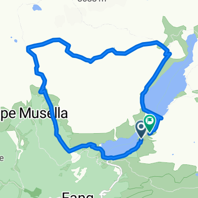
Anello del Lago Palù
A cycling route starting in Lanzada, Lombardy, Italy.
Overview
About this route
- -:--
- Duration
- 3.7 km
- Distance
- 83 m
- Ascent
- 83 m
- Descent
- ---
- Avg. speed
- ---
- Max. altitude
Continue with Bikemap
Use, edit, or download this cycling route
You would like to ride Anello del Lago Palù or customize it for your own trip? Here is what you can do with this Bikemap route:
Free features
- Save this route as favorite or in collections
- Copy & plan your own version of this route
- Sync your route with Garmin or Wahoo
Premium features
Free trial for 3 days, or one-time payment. More about Bikemap Premium.
- Navigate this route on iOS & Android
- Export a GPX / KML file of this route
- Create your custom printout (try it for free)
- Download this route for offline navigation
Discover more Premium features.
Get Bikemap PremiumFrom our community
Other popular routes starting in Lanzada
 VUT - Valmalenco Ultra trail
- Distance
- 87.4 km
- Ascent
- 4,464 m
- Descent
- 4,464 m
- Location
- Lanzada, Lombardy, Italy
 24agosto cima sassa
- Distance
- 10.5 km
- Ascent
- 1,274 m
- Descent
- 1,274 m
- Location
- Lanzada, Lombardy, Italy
 Route in Lanzada
- Distance
- 13.7 km
- Ascent
- 1,068 m
- Descent
- 1,062 m
- Location
- Lanzada, Lombardy, Italy
 Da Strada senza nome, Lanzada a Strada senza nome, Lanzada
- Distance
- 6.4 km
- Ascent
- 855 m
- Descent
- 907 m
- Location
- Lanzada, Lombardy, Italy
 Percorso rilassato in Lanzada
- Distance
- 4.5 km
- Ascent
- 389 m
- Descent
- 92 m
- Location
- Lanzada, Lombardy, Italy
 46.296° N 9.929° W a 46.297° N 9.944° W
- Distance
- 2.3 km
- Ascent
- 504 m
- Descent
- 332 m
- Location
- Lanzada, Lombardy, Italy
 Da Lanzada a Lanzada
- Distance
- 7.4 km
- Ascent
- 365 m
- Descent
- 413 m
- Location
- Lanzada, Lombardy, Italy
 Chiesa - Zoia
- Distance
- 15.2 km
- Ascent
- 1,178 m
- Descent
- 156 m
- Location
- Lanzada, Lombardy, Italy
Open it in the app