

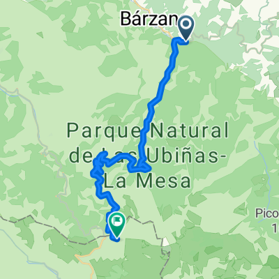
ALTO DE LA COBERTORIA (por Bárzana)
A cycling route starting in Bárzana, Principality of Asturias, Spain.
Overview
About this route
- -:--
- Duration
- 9.7 km
- Distance
- 725 m
- Ascent
- 9 m
- Descent
- ---
- Avg. speed
- ---
- Max. altitude

Route quality
Waytypes & surfaces along the route
Waytypes
Quiet road
0.4 km
(4 %)
Access road
0.3 km
(3 %)
Surfaces
Paved
9.3 km
(96 %)
Asphalt
9.3 km
(96 %)
Undefined
0.4 km
(4 %)
Continue with Bikemap
Use, edit, or download this cycling route
You would like to ride ALTO DE LA COBERTORIA (por Bárzana) or customize it for your own trip? Here is what you can do with this Bikemap route:
Free features
- Save this route as favorite or in collections
- Copy & plan your own version of this route
- Sync your route with Garmin or Wahoo
Premium features
Free trial for 3 days, or one-time payment. More about Bikemap Premium.
- Navigate this route on iOS & Android
- Export a GPX / KML file of this route
- Create your custom printout (try it for free)
- Download this route for offline navigation
Discover more Premium features.
Get Bikemap PremiumFrom our community
Other popular routes starting in Bárzana
 Ponferrada - Alto de Gamoniteiro
- Distance
- 186.3 km
- Ascent
- 3,005 m
- Descent
- 4,280 m
- Location
- Bárzana, Principality of Asturias, Spain
 Kalendarz The Climb 2020
- Distance
- 5,441.3 km
- Ascent
- 8,794 m
- Descent
- 10,345 m
- Location
- Bárzana, Principality of Asturias, Spain
 ERMITA del ALBA, por Bárzana
- Distance
- 6.9 km
- Ascent
- 819 m
- Descent
- 59 m
- Location
- Bárzana, Principality of Asturias, Spain
 TROBANIELLO, por Quirós
- Distance
- 16.9 km
- Ascent
- 1,178 m
- Descent
- 77 m
- Location
- Bárzana, Principality of Asturias, Spain
 Bárzana, Cobertoria por las Llanas, Gamoniteiro, Bárzana, Ermita de Alba, Bárzana.
- Distance
- 64.9 km
- Ascent
- 2,099 m
- Descent
- 2,102 m
- Location
- Bárzana, Principality of Asturias, Spain
 Bárzana - San Emiliano
- Distance
- 21.7 km
- Ascent
- 1,857 m
- Descent
- 712 m
- Location
- Bárzana, Principality of Asturias, Spain
 Gamoniteiru por Lindes y Cortes
- Distance
- 75.9 km
- Ascent
- 1,673 m
- Descent
- 1,768 m
- Location
- Bárzana, Principality of Asturias, Spain
 Senda del Oso completa, Santa Marina - Tuñón - Entrago
- Distance
- 44 km
- Ascent
- 1,232 m
- Descent
- 1,271 m
- Location
- Bárzana, Principality of Asturias, Spain
Open it in the app