

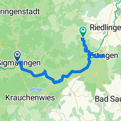
Donauradweg DE 3
A cycling route starting in Sigmaringen, Baden-Wurttemberg, Germany.
Overview
About this route
Sigmaringen
Sigmaringendorf
Scheer
Hundersingen
Riedlingen
Bechingen
Zwiefaltendorf
Datthausen
Mittenhausen
Rechtenstein
Obermarchtal
Untermarchtal
Algershofen
Munderkingen
Rottenacker
Dettingen
Ehingen
Nasgenstadt
Griesingen
Ersingen
- -:--
- Duration
- 82.6 km
- Distance
- 277 m
- Ascent
- 369 m
- Descent
- ---
- Avg. speed
- ---
- Max. altitude

Route quality
Waytypes & surfaces along the route
Waytypes
Quiet road
22.3 km
(27 %)
Road
19.9 km
(24 %)
Surfaces
Paved
52.3 km
(63 %)
Unpaved
5.5 km
(7 %)
Asphalt
49.4 km
(60 %)
Gravel
4.6 km
(6 %)
Continue with Bikemap
Use, edit, or download this cycling route
You would like to ride Donauradweg DE 3 or customize it for your own trip? Here is what you can do with this Bikemap route:
Free features
- Save this route as favorite or in collections
- Copy & plan your own version of this route
- Split it into stages to create a multi-day tour
- Sync your route with Garmin or Wahoo
Premium features
Free trial for 3 days, or one-time payment. More about Bikemap Premium.
- Navigate this route on iOS & Android
- Export a GPX / KML file of this route
- Create your custom printout (try it for free)
- Download this route for offline navigation
Discover more Premium features.
Get Bikemap PremiumFrom our community
Other popular routes starting in Sigmaringen
 Donauradweg DE 3
- Distance
- 82.6 km
- Ascent
- 277 m
- Descent
- 369 m
- Location
- Sigmaringen, Baden-Wurttemberg, Germany
 Lange Ausfahrt vom 20. Oktober, 11:25
- Distance
- 39.8 km
- Ascent
- 80 m
- Descent
- 122 m
- Location
- Sigmaringen, Baden-Wurttemberg, Germany
 Sigmaringen
- Distance
- 114.2 km
- Ascent
- 747 m
- Descent
- 757 m
- Location
- Sigmaringen, Baden-Wurttemberg, Germany
 Sigmaringen, Donauradweg bis Mengen, Zielfinger Seen, über Wildpark Josefslust zurück nach Sigmaringen.
- Distance
- 31.9 km
- Ascent
- 1,498 m
- Descent
- 1,494 m
- Location
- Sigmaringen, Baden-Wurttemberg, Germany
 From Sigmaringen to Altheim
- Distance
- 38.7 km
- Ascent
- 269 m
- Descent
- 279 m
- Location
- Sigmaringen, Baden-Wurttemberg, Germany
 Tour 1 - Schmeiental-Tour
- Distance
- 19.9 km
- Ascent
- 433 m
- Descent
- 430 m
- Location
- Sigmaringen, Baden-Wurttemberg, Germany
 Tag 2 Sigmaringen nach Riedheim
- Distance
- 138 km
- Ascent
- 1,026 m
- Descent
- 1,150 m
- Location
- Sigmaringen, Baden-Wurttemberg, Germany
 Donauradweg Siegmaringen - Riedlingen
- Distance
- 35.3 km
- Ascent
- 148 m
- Descent
- 203 m
- Location
- Sigmaringen, Baden-Wurttemberg, Germany
Open it in the app