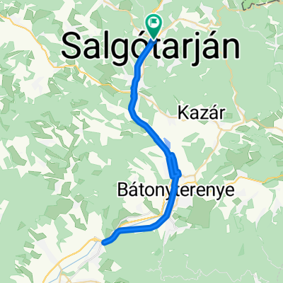
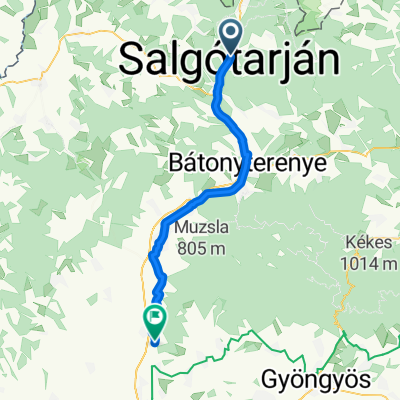
Északi Zöld 14
A cycling route starting in Salgótarján, Nógrád megye, Hungary.
Overview
About this route
Északi Zöld
Szilváskő
Somoskőújfalu
- -:--
- Duration
- 22.2 km
- Distance
- 540 m
- Ascent
- 754 m
- Descent
- ---
- Avg. speed
- ---
- Avg. speed
Route quality
Waytypes & surfaces along the route
Waytypes
Path
10.1 km
(45 %)
Track
10.1 km
(45 %)
Surfaces
Paved
0.8 km
(3 %)
Unpaved
16.2 km
(73 %)
Ground
12.6 km
(57 %)
Gravel
3.5 km
(16 %)
Continue with Bikemap
Use, edit, or download this cycling route
You would like to ride Északi Zöld 14 or customize it for your own trip? Here is what you can do with this Bikemap route:
Free features
- Save this route as favorite or in collections
- Copy & plan your own version of this route
- Sync your route with Garmin or Wahoo
Premium features
Free trial for 3 days, or one-time payment. More about Bikemap Premium.
- Navigate this route on iOS & Android
- Export a GPX / KML file of this route
- Create your custom printout (try it for free)
- Download this route for offline navigation
Discover more Premium features.
Get Bikemap PremiumFrom our community
Other popular routes starting in Salgótarján
- Medves-Tarna-vidék
- Distance
- 75.5 km
- Ascent
- 554 m
- Descent
- 556 m
- Location
- Salgótarján, Nógrád megye, Hungary
- Boszorkánykő
- Distance
- 21.5 km
- Ascent
- 574 m
- Descent
- 575 m
- Location
- Salgótarján, Nógrád megye, Hungary
- Salgótarján-Esztergom (5 nap)
- Distance
- 218.5 km
- Ascent
- 901 m
- Descent
- 966 m
- Location
- Salgótarján, Nógrád megye, Hungary
- S.tarján - Mátrakeresztes
- Distance
- 71 km
- Ascent
- 662 m
- Descent
- 661 m
- Location
- Salgótarján, Nógrád megye, Hungary
- megintfejlettcucc
- Distance
- 129.9 km
- Ascent
- 878 m
- Descent
- 1,048 m
- Location
- Salgótarján, Nógrád megye, Hungary
- Salgótarján- Tachty tó
- Distance
- 81.3 km
- Ascent
- 736 m
- Descent
- 737 m
- Location
- Salgótarján, Nógrád megye, Hungary
- OKKT II.3. Salgótarján-Eger
- Distance
- 131.5 km
- Ascent
- 1,324 m
- Descent
- 1,412 m
- Location
- Salgótarján, Nógrád megye, Hungary
- tarjan kupa
- Distance
- 26.6 km
- Ascent
- 257 m
- Descent
- 257 m
- Location
- Salgótarján, Nógrád megye, Hungary
Open it in the app