
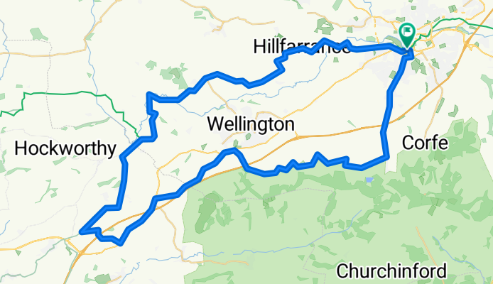
Taunton to sampford peverrell 57.32
A cycling route starting in Taunton, England, United Kingdom.
Overview
About this route
- -:--
- Duration
- 57.3 km
- Distance
- 356 m
- Ascent
- 356 m
- Descent
- ---
- Avg. speed
- ---
- Max. altitude
Route quality
Waytypes & surfaces along the route
Waytypes
Quiet road
36.7 km
(64 %)
Road
7.5 km
(13 %)
Surfaces
Paved
10.3 km
(18 %)
Unpaved
7.5 km
(13 %)
Gravel
6.3 km
(11 %)
Paved (undefined)
5.2 km
(9 %)
Continue with Bikemap
Use, edit, or download this cycling route
You would like to ride Taunton to sampford peverrell 57.32 or customize it for your own trip? Here is what you can do with this Bikemap route:
Free features
- Save this route as favorite or in collections
- Copy & plan your own version of this route
- Sync your route with Garmin or Wahoo
Premium features
Free trial for 3 days, or one-time payment. More about Bikemap Premium.
- Navigate this route on iOS & Android
- Export a GPX / KML file of this route
- Create your custom printout (try it for free)
- Download this route for offline navigation
Discover more Premium features.
Get Bikemap PremiumFrom our community
Other popular routes starting in Taunton
 boxing day walk
- Distance
- 13 km
- Ascent
- 243 m
- Descent
- 239 m
- Location
- Taunton, England, United Kingdom
 Somerset hills
- Distance
- 40.8 km
- Ascent
- 584 m
- Descent
- 581 m
- Location
- Taunton, England, United Kingdom
 TAU>WELLI>MILV>TAU
- Distance
- 31.8 km
- Ascent
- 182 m
- Descent
- 182 m
- Location
- Taunton, England, United Kingdom
 Bri -> Tau (flat-er)
- Distance
- 129.9 km
- Ascent
- 596 m
- Descent
- 513 m
- Location
- Taunton, England, United Kingdom
 day3 - taunton....to Bude (final destination!)
- Distance
- 121.8 km
- Ascent
- 762 m
- Descent
- 774 m
- Location
- Taunton, England, United Kingdom
 Ride 22 April
- Distance
- 31 km
- Ascent
- 126 m
- Descent
- 127 m
- Location
- Taunton, England, United Kingdom
 West Buckland and Welly Weave
- Distance
- 50.3 km
- Ascent
- 397 m
- Descent
- 397 m
- Location
- Taunton, England, United Kingdom
 Quantock foothills to Stogumber and back
- Distance
- 42 km
- Ascent
- 438 m
- Descent
- 438 m
- Location
- Taunton, England, United Kingdom
Open it in the app