

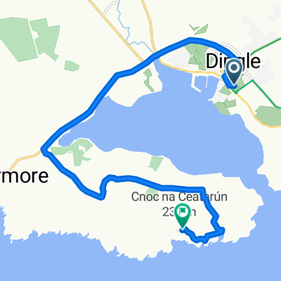
Ire1_Etp13 Dingle-Killarney
A cycling route starting in Dingle, Munster, Ireland.
Overview
About this route
Einfach zu fahrende Strecke ohne Besonderheiten.
- -:--
- Duration
- 66.8 km
- Distance
- 336 m
- Ascent
- 324 m
- Descent
- ---
- Avg. speed
- ---
- Max. altitude
Route highlights
Points of interest along the route
Accommodation after 66.8 km
BB Cloghroe Sauber und Frühstück ok
Continue with Bikemap
Use, edit, or download this cycling route
You would like to ride Ire1_Etp13 Dingle-Killarney or customize it for your own trip? Here is what you can do with this Bikemap route:
Free features
- Save this route as favorite or in collections
- Copy & plan your own version of this route
- Sync your route with Garmin or Wahoo
Premium features
Free trial for 3 days, or one-time payment. More about Bikemap Premium.
- Navigate this route on iOS & Android
- Export a GPX / KML file of this route
- Create your custom printout (try it for free)
- Download this route for offline navigation
Discover more Premium features.
Get Bikemap PremiumFrom our community
Other popular routes starting in Dingle
 Slea Head
- Distance
- 39.3 km
- Ascent
- 286 m
- Descent
- 286 m
- Location
- Dingle, Munster, Ireland
 Slea Head Loop
- Distance
- 50.3 km
- Ascent
- 2,893 m
- Descent
- 2,885 m
- Location
- Dingle, Munster, Ireland
 Dingle a Killarney
- Distance
- 66.3 km
- Ascent
- 417 m
- Descent
- 388 m
- Location
- Dingle, Munster, Ireland
 Dingle - Dingle
- Distance
- 40.1 km
- Ascent
- 423 m
- Descent
- 423 m
- Location
- Dingle, Munster, Ireland
 012 Tour of the Dingle Peninsula
- Distance
- 55.8 km
- Ascent
- 324 m
- Descent
- 324 m
- Location
- Dingle, Munster, Ireland
 Dingle
- Distance
- 56.1 km
- Ascent
- 540 m
- Descent
- 540 m
- Location
- Dingle, Munster, Ireland
 Dingle peninsula
- Distance
- 9.8 km
- Ascent
- 302 m
- Descent
- 149 m
- Location
- Dingle, Munster, Ireland
 Tag 31: Dingle - Mündung Shannon
- Distance
- 92.4 km
- Ascent
- 559 m
- Descent
- 858 m
- Location
- Dingle, Munster, Ireland
Open it in the app