

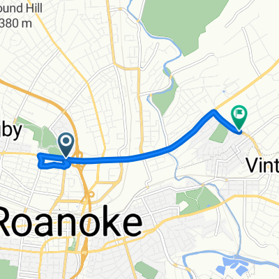
Bikeshare by RIDE Solutions
A cycling route starting in Roanoke, Virginia, United States.
Overview
About this route
- -:--
- Duration
- 34.6 km
- Distance
- 112 m
- Ascent
- 123 m
- Descent
- ---
- Avg. speed
- ---
- Max. altitude

Continue with Bikemap
Use, edit, or download this cycling route
You would like to ride Bikeshare by RIDE Solutions or customize it for your own trip? Here is what you can do with this Bikemap route:
Free features
- Save this route as favorite or in collections
- Copy & plan your own version of this route
- Sync your route with Garmin or Wahoo
Premium features
Free trial for 3 days, or one-time payment. More about Bikemap Premium.
- Navigate this route on iOS & Android
- Export a GPX / KML file of this route
- Create your custom printout (try it for free)
- Download this route for offline navigation
Discover more Premium features.
Get Bikemap PremiumFrom our community
Other popular routes starting in Roanoke
 Kirk Avenue Southwest 18b, Roanoke to Peppers Ferry Road 150, Wytheville
- Distance
- 140.6 km
- Ascent
- 2,155 m
- Descent
- 1,729 m
- Location
- Roanoke, Virginia, United States
 Roanoke - Blue Ridge Parkway - Galax 166 km
- Distance
- 165.9 km
- Ascent
- 1,413 m
- Descent
- 976 m
- Location
- Roanoke, Virginia, United States
 Recovered Route
- Distance
- 5.3 km
- Ascent
- 51 m
- Descent
- 39 m
- Location
- Roanoke, Virginia, United States
 Roanoke/Peaks of Otter
- Distance
- 62.5 km
- Ascent
- 838 m
- Descent
- 387 m
- Location
- Roanoke, Virginia, United States
 USA Etape 4 Roanoke-Fayetteville
- Distance
- 218.1 km
- Ascent
- 2,149 m
- Descent
- 1,912 m
- Location
- Roanoke, Virginia, United States
 testing
- Distance
- 0.7 km
- Ascent
- 12 m
- Descent
- 4 m
- Location
- Roanoke, Virginia, United States
 Bikeshare by RIDE Solutions
- Distance
- 34.6 km
- Ascent
- 112 m
- Descent
- 123 m
- Location
- Roanoke, Virginia, United States
 Lee Highway to Reserve Avenue Southwest
- Distance
- 7.4 km
- Ascent
- 48 m
- Descent
- 30 m
- Location
- Roanoke, Virginia, United States
Open it in the app